-
Land Use. Forest Area. Cambodia, Laos, Myanmar, Thailand & Vietnam (2000-2015)
 Cambodia, Lao People's Democratic Republic, Myanmar, Thailand, Viet Nam
June 30, 2018
Source: © FAO 2015 Land Use. Forest Area....
This dataset contains data from the FAOSTAT for the proportion of land use related to forests in Cambodia, Laos, Myanmar, Thailand & Vietnam. It covers the years from 2000 to 20...
Cambodia, Lao People's Democratic Republic, Myanmar, Thailand, Viet Nam
June 30, 2018
Source: © FAO 2015 Land Use. Forest Area....
This dataset contains data from the FAOSTAT for the proportion of land use related to forests in Cambodia, Laos, Myanmar, Thailand & Vietnam. It covers the years from 2000 to 20...
-
Official result of fourth mandate of commune/sangkat council election in 2017
 Cambodia
July 19, 2017
Source: National Election Committee (NEC),...
The official result of the fourth mandate of the 2017 commune/sangkat council election was released on June 25, 2017 by the National Election Committee (NEC). It covers all the ...
Cambodia
July 19, 2017
Source: National Election Committee (NEC),...
The official result of the fourth mandate of the 2017 commune/sangkat council election was released on June 25, 2017 by the National Election Committee (NEC). It covers all the ...
-
ELC and SEZ and Roads
Cambodia
December 6, 2015
Source: Save Cambodia's Wildlife. Atlas of Cambodia: maps on...
 This dataset provides known locations of Economic Land Concessions, Special Economic Zones and national level roads. It was compiled from the Economic Census of Cambodia (2011),...
-
Public services for transportation
Cambodia
December 23, 2016
Source: http://www.ncdd.gov.kh/jdownloads/Prakas/prokas_mef__mof.pdf
This dataset contains a list of public services provided by Ministry of Public Works and Transport, focusing on motorcycle and automobile. There are three main categories of ser...
-
Sanitation coverage data in Cambodia
Cambodia
August 10, 2016
Source: WaterSHED Cambodia. "Sanitation data coverage." Retrieved from...
This is a statistical spreadsheet detailing the data of the latrines in Battambang, Kampong Cham, Kampong Chhnang, Kampong Speu, Kampong Thom, Tboung Khmum, Pailin and Takeo, wh...
-
National grid, import of energy, consumption of energy, hydro-electric dams
Cambodia
December 6, 2015
Source: Ministry of Industry, Mines and Energy, Department of Geography:...
 The dataset provides location of national electricity grid, hydropower dam locations, and energy import and consumption rates. Data were provided to ODC in vector format by Save...
-
Prey Lang protected forest and biodiversity conservation area
Cambodia
December 6, 2015
Source: Open Development Cambodia, contact@opendevcam.net, +855 23 221...
 This dataset shows the proposed boundary of the Prey Lang protected forest and biodiversity conservation area. The data was collected from many sources by ODC’s mappers such as ...
-
Prek Toal bird sanctuary biosphere reserve
Cambodia
December 6, 2015
Source: Save Cambodia's Wildlife. In Atlas of Cambodia: maps on...
 The Prek Toal Bird Sanctuary Biosphere Reserve is represented in this dataset. Dataset provided to Open Development Cambodia (ODC) by Save Cambodia's Wildlife's Atlas Working Gr...
-
Oddar Meanchey REDD+
Cambodia
December 6, 2015
Source: Pact Cambodia (2013) http://www.pactcambodia.org/
Aruna...
 This dataset represents the community forest boundaries that combine to form the Oddar Meanchey REDD+ initiative. Data were provided to ODC by Save Cambodia's Wildlife's Atlas W...
-
Oil & gas blocks and mining
Cambodia
December 6, 2015
Source: Save Cambodia's Wildlife. Atlas of Cambodia: maps on...
 These combined dataset provides information on the location of oil and gas blocks as well as mining concessions. Data were provided to ODC by Save Cambodia's Wildlife's Atlas Wo...
-
Hectare forest cover by province in Cambodia (1973 - 2014)
Cambodia
April 1, 2015
Source: Open Development Cambodia. "Forest cover in Cambodia (1973 -...
The dataset describes hectare forest cover by province in Cambodia in 1973, 1989, 2000, 2004, 2009, 2013 and 2014. This dataset was derived from ODC forest cover in Cambodia ...
-
Phnom Penh urban sprawl timeline (2003-2013)
Cambodia
December 6, 2015
Source: Landsat NASA 2003/13 http://landsat.gsfc.nasa.gov/
 Landsat satellite images are presented in this dataset of Phnom Penh detailing land use change in the year 2003 and 2013. Dataset were provided to Open Development Cambodia (ODC...
-
Pursat communal land use planning (CLUP) atlas 2009
Cambodia
April 18, 2017
Source: Ministry of Land Management, Urban Planning and Construction...
 Pursat communal land use planning(CLUP) atlas (Chamraeun Phal, Kbal Trach, Me Tuek, Phteah Rung, Prongil, Roleab, Ta Lou, Tnaot Chum commune) is communal land use planning extra...
-
Koh Kong communal land use planning (CLUP) atlas 2009
Cambodia
April 18, 2017
Source: Ministry of Land Management, Urban Planning and Construction...
 Koh Kong communal land use planning(CLUP) atlas (Andong Tuek, Chrouy Pras, Smach Mean Chey, Stung Veng, Tma Sa, and Trapeang Rung commune) is communal land use planning extracte...
-
Ratanakiri communal land use planning (CLUP) atlas 2009
Cambodia
April 18, 2017
Source: Ministry of Land Management, Urban Planning and Construction...
 Ratanakiri communal land use planning(CLUP) atlas (Aekakpheap, Ka Choun, Pong, Sameaki, Serei Mongkol, and Toen commune) is communal land use planning extracted from 2009 contai...
-
Siem Reap communal land use planning (CLUP) atlas 2009
Cambodia
April 18, 2017
Source: Ministry of Land Management, Urban Planning and Construction...
 Siem Reap communal land use planning(CLUP) atlas (Chan Sar, Doun Peaeng, Leang Dai, Nokor Pheas , Popel, Srae Khvav, Svay Chek, Tayaek commune) is communal land use planning ext...
-
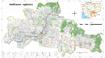
Kampong Speu commune land use planning (CLUP) atlas 2009
Cambodia
March 29, 2017
Source: Ministry of Land Management, Urban Planning and Construction...
Kampong Speu commune land use planning(CLUP) atlas (Kiri Vaon, Moha Sang, Honorom, Prabei Mom, Prey Khmeng, and Yea Angk commune) is communal land use planning extracted from 20...
-
Kampong Cham communal land use planning (CLUP) atlas 2009
Cambodia
April 18, 2017
Source: Ministry of Land Management, Urban Planning and Construction...
 Kampong Cham communal land use planning(CLUP) atlas (Chikor, Moung Riev, Roang, and Srak commune) is communal land use planning extracted from 2009 contained both detailed curre...
-
Mondulkiri communal land use planning (CLUP) atlas 2009
Cambodia
April 18, 2017
Source: Ministry of Land Management, Urban Planning and Construction...
 Mondulkiri communal land use planning(CLUP) atlas (Dak Dam, Pu Chri, Saen Monourom, Srae Ampum, Srae Khtum, and Srae Preah commune) is communal land use planning extracted from ...
-
Preah Sihanouk communal land use planning (CLUP) atlas 2009
Cambodia
April 18, 2017
Source: Ministry of Land Management, Urban Planning and Construction...
Preah Sihanouk communal land use planning(CLUP) atlas (Angdoung Thma, Kampenh, Outreh, Samrong, and Tomnob Rolok commune) is communal land use planning extracted from 2009 conta...