-
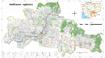
Pursat communal land use planning (CLUP) atlas 2009
 Cambodia
April 18, 2017
Source: Ministry of Land Management, Urban Planning and Construction...
Cambodia
April 18, 2017
Source: Ministry of Land Management, Urban Planning and Construction...
 Pursat communal land use planning(CLUP) atlas (Chamraeun Phal, Kbal Trach, Me Tuek, Phteah Rung, Prongil, Roleab, Ta Lou, Tnaot Chum commune) is communal land use planning extra...
-
Koh Kong communal land use planning (CLUP) atlas 2009
Cambodia
April 18, 2017
Source: Ministry of Land Management, Urban Planning and Construction...
 Koh Kong communal land use planning(CLUP) atlas (Andong Tuek, Chrouy Pras, Smach Mean Chey, Stung Veng, Tma Sa, and Trapeang Rung commune) is communal land use planning extracte...
-
Siem Reap communal land use planning (CLUP) atlas 2009
Cambodia
April 18, 2017
Source: Ministry of Land Management, Urban Planning and Construction...
 Siem Reap communal land use planning(CLUP) atlas (Chan Sar, Doun Peaeng, Leang Dai, Nokor Pheas , Popel, Srae Khvav, Svay Chek, Tayaek commune) is communal land use planning ext...
-
Kampong Cham communal land use planning (CLUP) atlas 2009
Cambodia
April 18, 2017
Source: Ministry of Land Management, Urban Planning and Construction...
 Kampong Cham communal land use planning(CLUP) atlas (Chikor, Moung Riev, Roang, and Srak commune) is communal land use planning extracted from 2009 contained both detailed curre...
-
Mondulkiri communal land use planning (CLUP) atlas 2009
Cambodia
April 18, 2017
Source: Ministry of Land Management, Urban Planning and Construction...
 Mondulkiri communal land use planning(CLUP) atlas (Dak Dam, Pu Chri, Saen Monourom, Srae Ampum, Srae Khtum, and Srae Preah commune) is communal land use planning extracted from ...
-
Kratie communal land use planning (CLUP) atlas 2009
Cambodia
April 18, 2017
Source: Ministry of Land Management, Urban Planning and Construction...
 Kratie communal land use planning(CLUP) atlas (Dar, Kbal Damrey, O Krieng, Ruessei Kaev, Saob, Srae Char, Svay Chreah, and Thmi commune) is communal land use planning extracted ...