-
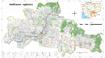
Economic land concessions (ELCs)
 Cambodia
November 13, 2023
Source: Reference documents for each ELCs are provided for download on the...
Cambodia
November 13, 2023
Source: Reference documents for each ELCs are provided for download on the...
 This dataset contains a list of ELCs in Cambodia with contract dates starting from 1996 to 2014. The list was updated in November 2017 to included adjustments to ELCs contracts ...
-
Land cover in Cambodia (2015-2023)
Cambodia
December 21, 2024
Source: Servir SEA: https://cambodia-me-servir.adpc.net/mapviewer
 The Cambodia national Land Cover time series (2015-2023) was derived from the Biophysical M&E Dashboard tool, being used by USAID/Cambodia to track performance and report on lan...
-
Commune database of Cambodia, commune-level (2011)
 Cambodia
December 5, 2023
Source: National Committee for Sub-National Democratic Development, Royal...
Cambodia
December 5, 2023
Source: National Committee for Sub-National Democratic Development, Royal...
 The Commune Database is produced by the NCDD (National Committee for Subnational Democratic Development). This file contains excerpts of the Database, namely quantitative data a...
-
Geology of Cambodia (2006)
Cambodia
September 23, 2016
Source: Save Cambodia's Wildlife. *Atlas of Cambodia: maps on...
 This dataset provides known locations of geolocial sites in Cambodia.Geographic data is encoded in the WGS 84 coordinate reference system. Data were provided to ODC in vector fo...
-
Mine/ERW casualties (2005- 2013)
Cambodia
June 30, 2020
Source: Office for the Coordination of Humanitarian Affairs (OCHA) in Asia...
 This dataset shows information about locations of casualties caused by explosive remnants of war (ERW) and mines from 2005 to 2013 across Cambodia. Plus, it also includes number...
-
Mine and Explosive Remnant of War (ERW) accident casualties (2016-2017)
Cambodia
June 30, 2020
Source: Monthly Report for December 2017 published by the Cambodian Mine...
 This dataset contains information, extracted from Monthly Report for December 2017 of Cambodia Mine/ERW Victim Information System (CMVIS) published by Cambodian Mine Action and...
-
Mine and Explosive Remnant of War (ERW) accident casualties (2018-2019)
Cambodia
June 23, 2020
Source: Monthly Report for March 2017 published by the Cambodian Mine...
 This dataset contains information, extracted from Monthly Report for October 2019 of Cambodia Mine/ERW Victim Information System (CMVIS) published by Cambodian Mine Action and ...
-
Systematic land registration in Cambodia (2013)
Cambodia
October 4, 15
Source: Ministry of Land Management, Urban Planning and Construction. Land...
 This dataset describes the status of systematic land registration in Cambodia's communes by March 2013, as given in the Cambodian Ministry of Land Management's Land Administrati...
-
Pursat communal land use planning (CLUP) atlas 2009
Cambodia
April 18, 2017
Source: Ministry of Land Management, Urban Planning and Construction...
 Pursat communal land use planning(CLUP) atlas (Chamraeun Phal, Kbal Trach, Me Tuek, Phteah Rung, Prongil, Roleab, Ta Lou, Tnaot Chum commune) is communal land use planning extra...
-
Koh Kong communal land use planning (CLUP) atlas 2009
Cambodia
April 18, 2017
Source: Ministry of Land Management, Urban Planning and Construction...
 Koh Kong communal land use planning(CLUP) atlas (Andong Tuek, Chrouy Pras, Smach Mean Chey, Stung Veng, Tma Sa, and Trapeang Rung commune) is communal land use planning extracte...
-
Ratanakiri communal land use planning (CLUP) atlas 2009
Cambodia
April 18, 2017
Source: Ministry of Land Management, Urban Planning and Construction...
 Ratanakiri communal land use planning(CLUP) atlas (Aekakpheap, Ka Choun, Pong, Sameaki, Serei Mongkol, and Toen commune) is communal land use planning extracted from 2009 contai...
-
Siem Reap communal land use planning (CLUP) atlas 2009
Cambodia
April 18, 2017
Source: Ministry of Land Management, Urban Planning and Construction...
 Siem Reap communal land use planning(CLUP) atlas (Chan Sar, Doun Peaeng, Leang Dai, Nokor Pheas , Popel, Srae Khvav, Svay Chek, Tayaek commune) is communal land use planning ext...
-
Kampong Cham communal land use planning (CLUP) atlas 2009
Cambodia
April 18, 2017
Source: Ministry of Land Management, Urban Planning and Construction...
 Kampong Cham communal land use planning(CLUP) atlas (Chikor, Moung Riev, Roang, and Srak commune) is communal land use planning extracted from 2009 contained both detailed curre...
-
Mondulkiri communal land use planning (CLUP) atlas 2009
Cambodia
April 18, 2017
Source: Ministry of Land Management, Urban Planning and Construction...
 Mondulkiri communal land use planning(CLUP) atlas (Dak Dam, Pu Chri, Saen Monourom, Srae Ampum, Srae Khtum, and Srae Preah commune) is communal land use planning extracted from ...
-
Kratie communal land use planning (CLUP) atlas 2009
Cambodia
April 18, 2017
Source: Ministry of Land Management, Urban Planning and Construction...
 Kratie communal land use planning(CLUP) atlas (Dar, Kbal Damrey, O Krieng, Ruessei Kaev, Saob, Srae Char, Svay Chreah, and Thmi commune) is communal land use planning extracted ...