-
Cambodia atlas of gender and environment
 Cambodia
March 2, 2018
Source: Cambodia atlas of gender and environment, The Asia Foundation
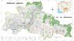
In 2017, the Asia Foundation initiated the “Atlas of Gender and Environment” project to provide a more in-depth understanding of how gender informs environment-related vulnerabi...
Cambodia
March 2, 2018
Source: Cambodia atlas of gender and environment, The Asia Foundation
In 2017, the Asia Foundation initiated the “Atlas of Gender and Environment” project to provide a more in-depth understanding of how gender informs environment-related vulnerabi...
-
Commune database of Cambodia, commune-level (2011)
 Cambodia
December 5, 2023
Source: National Committee for Sub-National Democratic Development, Royal...
Cambodia
December 5, 2023
Source: National Committee for Sub-National Democratic Development, Royal...
 The Commune Database is produced by the NCDD (National Committee for Subnational Democratic Development). This file contains excerpts of the Database, namely quantitative data a...
-
ASTER global digital elevation model (ASTER GDEM) in Cambodia
Cambodia
February 23, 2023
Source:
 The dataset of ASTER Global Digital Elevation Model (ASTER GDEM) places great emphasis on topographic information of the global terrain. As the ASTER was created with the global...
-
Hydropower reservoirs in Cambodia (1999-2010)
Cambodia
November 25, 2015
Source: Aruna Technology. Rapid Assessment of Prey Land Forest Final...
 This dataset describes the information of hydropower reservoirs for each of Cambodia’s province from 2009 to 2010. The data was collected from many sources by ODC’s mappers such...
-
Protected areas and forests (2013)
Cambodia
December 5, 2015
Source: Wildlife Conservation Society, Conservation International,...
 This datasset provides boundaries, land size and status of protected areas in Cambodia. Geographic data is encoded in the WGS 84 coordinate reference system. Data were provided ...
-
Pursat communal land use planning (CLUP) atlas 2009
Cambodia
April 18, 2017
Source: Ministry of Land Management, Urban Planning and Construction...
 Pursat communal land use planning(CLUP) atlas (Chamraeun Phal, Kbal Trach, Me Tuek, Phteah Rung, Prongil, Roleab, Ta Lou, Tnaot Chum commune) is communal land use planning extra...
-
Koh Kong communal land use planning (CLUP) atlas 2009
Cambodia
April 18, 2017
Source: Ministry of Land Management, Urban Planning and Construction...
 Koh Kong communal land use planning(CLUP) atlas (Andong Tuek, Chrouy Pras, Smach Mean Chey, Stung Veng, Tma Sa, and Trapeang Rung commune) is communal land use planning extracte...
-
Ratanakiri communal land use planning (CLUP) atlas 2009
Cambodia
April 18, 2017
Source: Ministry of Land Management, Urban Planning and Construction...
 Ratanakiri communal land use planning(CLUP) atlas (Aekakpheap, Ka Choun, Pong, Sameaki, Serei Mongkol, and Toen commune) is communal land use planning extracted from 2009 contai...
-
Siem Reap communal land use planning (CLUP) atlas 2009
Cambodia
April 18, 2017
Source: Ministry of Land Management, Urban Planning and Construction...
 Siem Reap communal land use planning(CLUP) atlas (Chan Sar, Doun Peaeng, Leang Dai, Nokor Pheas , Popel, Srae Khvav, Svay Chek, Tayaek commune) is communal land use planning ext...
-
Kampong Speu commune land use planning (CLUP) atlas 2009
Cambodia
March 29, 2017
Source: Ministry of Land Management, Urban Planning and Construction...
Kampong Speu commune land use planning(CLUP) atlas (Kiri Vaon, Moha Sang, Honorom, Prabei Mom, Prey Khmeng, and Yea Angk commune) is communal land use planning extracted from 20...
-
Kampong Cham communal land use planning (CLUP) atlas 2009
Cambodia
April 18, 2017
Source: Ministry of Land Management, Urban Planning and Construction...
 Kampong Cham communal land use planning(CLUP) atlas (Chikor, Moung Riev, Roang, and Srak commune) is communal land use planning extracted from 2009 contained both detailed curre...
-
Mondulkiri communal land use planning (CLUP) atlas 2009
Cambodia
April 18, 2017
Source: Ministry of Land Management, Urban Planning and Construction...
 Mondulkiri communal land use planning(CLUP) atlas (Dak Dam, Pu Chri, Saen Monourom, Srae Ampum, Srae Khtum, and Srae Preah commune) is communal land use planning extracted from ...
-
Preah Sihanouk communal land use planning (CLUP) atlas 2009
Cambodia
April 18, 2017
Source: Ministry of Land Management, Urban Planning and Construction...
Preah Sihanouk communal land use planning(CLUP) atlas (Angdoung Thma, Kampenh, Outreh, Samrong, and Tomnob Rolok commune) is communal land use planning extracted from 2009 conta...
-
Kep communal land use planning (CLUP) atlas 2009
Cambodia
April 18, 2017
Source: Ministry of Land Management, Urban Planning and Construction...
Kep communal land use planning(CLUP) atlas (Angkaol, Ou Krasar, and Pong Tuek commune) is communal land use planning extracted from 2009 contained both detailed current land us...
-
Kratie communal land use planning (CLUP) atlas 2009
Cambodia
April 18, 2017
Source: Ministry of Land Management, Urban Planning and Construction...
 Kratie communal land use planning(CLUP) atlas (Dar, Kbal Damrey, O Krieng, Ruessei Kaev, Saob, Srae Char, Svay Chreah, and Thmi commune) is communal land use planning extracted ...