-
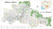
Natural protected areas and biodiversity conservation corridors
 Cambodia
April 6, 2019
Source: GIS portal of the Ministry of Environment of...
Cambodia
April 6, 2019
Source: GIS portal of the Ministry of Environment of...
 Biodiversity conservation corridors are uninterrupted areas of forest and other habitats rich in biodiversity that link between the natural protected areas (NPA). This dataset c...
-
Baseline survey on mine/ERW (2009-2014)
Cambodia
April 2, 2020
Source: Office for the Coordination of Humanitarian Affairs (OCHA) in Asia...
 This baseline survey data shows information about contamination locations of explosive remnants of war (ERW) and mines from 2009 to 2014. The data also included fear levels, pro...
-
Hydroelectric sites in Cambodia (1999-2014)
Cambodia
October 4, 2015
Source: Electricite du Cambodge. Annual Report 2014
Ministry of Industry,...
 This dataset describes the information of hydroelectric sites (substations) for each of Cambodia’s province from 1999 to 2014. The data was collected from many sources by ODC’s ...
-
Hydropower reservoirs in Cambodia (1999-2010)
Cambodia
November 25, 2015
Source: Aruna Technology. Rapid Assessment of Prey Land Forest Final...
 This dataset describes the information of hydropower reservoirs for each of Cambodia’s province from 2009 to 2010. The data was collected from many sources by ODC’s mappers such...
-
Eviction and relocation hotspots in Cambodia (2013)
Cambodia
October 4, 2015
Source: Sahmakum Teang Tnaut and Save Cambodia's Wildlife. Atlas of...
 This asset provides the area of eviction hotspots and relocation hotspots in Cambodia, with raster value that demonstrates number of families affected, given by Sahmakum Teang T...
-
Gene-ecological zones of Cambodia (2003)
Cambodia
October 4, 15
Source: Forestry Administration, Cambodia Tree Seed Project....
 The dataset provides map boundaries of around 10 different zones that can be delineated and that each zone can be characterized and differentiated on the basis of its geographic...
-
Systematic land registration in Cambodia (2013)
Cambodia
October 4, 15
Source: Ministry of Land Management, Urban Planning and Construction. Land...
 This dataset describes the status of systematic land registration in Cambodia's communes by March 2013, as given in the Cambodian Ministry of Land Management's Land Administrati...
-
Climate change vulnerability in Cambodia (2010)
Cambodia
October 4, 2015
Source: Economy and Environment Program for Southeast Asia, 2010. Save...
 This dataset provides a climate change vulnerability index value for each province in Cambodia, as determined by the Economy and Environment Program for Southeast Asia, a progra...
-
Community forests in Cambodia (2013)
Cambodia
December 5, 2015
Source: Forestry Administration, Government of Cambodia. Phnom Penh,...
 This asset contains the location and status of applications for community forestry status in Cambodia in 2013, given by the Forestry Administration. Geographic data is encoded i...
-
Assessment of undiscovered copper resources in Cambodia
Cambodia
March 15, 2017
Source: Zürcher, Lukas, Bookstrom, A.A., Hammarstrom, J.M., Mars, J.C.,...
 Deposits, prospects, and permissive tracts for porphyry and sediment-hosted copper resources Cambodia, with estimates of undiscovered copper resources. Copper resources are rep...
-
Eastern plains protected landscape (EPL) in Cambodia
Cambodia
December 1, 2014
Source: Wildlife Conservation Society, Conservation International,...
 This dataset describes the eastern plains landscape (EPL), which covers an area over 30,000 square kilometers and spans four provinces (Ratank Kiri, Mondul Kiri, Kratie and Stun...
-
Wetlands in Cambodia
Cambodia
July 29, 2019
Source: Downloaded from...
 This dataset contains information of land areas and location of wetlands in Cambodia which was downloaded from World Food Programme GeoNode (WFPGeoNode) using data in 2013 from ...
-
US bombing in Cambodia (1965-1975)
Cambodia
April 3, 2017
Source: The US bombing database was released by the US Embassy in Cambodia...
 This spatial data shows the 115,273 sites targeted in the 231,467 US bombing sorties flown over Cambodia between October 1965 and May 1975, dropping 2,757,107 tons of munitions....
-
Protected areas and forests (2013)
Cambodia
December 5, 2015
Source: Wildlife Conservation Society, Conservation International,...
 This datasset provides boundaries, land size and status of protected areas in Cambodia. Geographic data is encoded in the WGS 84 coordinate reference system. Data were provided ...
-
Oil & gas blocks and mining
Cambodia
December 6, 2015
Source: Save Cambodia's Wildlife. Atlas of Cambodia: maps on...
 These combined dataset provides information on the location of oil and gas blocks as well as mining concessions. Data were provided to ODC by Save Cambodia's Wildlife's Atlas Wo...
-
Pursat communal land use planning (CLUP) atlas 2009
Cambodia
April 18, 2017
Source: Ministry of Land Management, Urban Planning and Construction...
 Pursat communal land use planning(CLUP) atlas (Chamraeun Phal, Kbal Trach, Me Tuek, Phteah Rung, Prongil, Roleab, Ta Lou, Tnaot Chum commune) is communal land use planning extra...
-
Koh Kong communal land use planning (CLUP) atlas 2009
Cambodia
April 18, 2017
Source: Ministry of Land Management, Urban Planning and Construction...
 Koh Kong communal land use planning(CLUP) atlas (Andong Tuek, Chrouy Pras, Smach Mean Chey, Stung Veng, Tma Sa, and Trapeang Rung commune) is communal land use planning extracte...
-
Ratanakiri communal land use planning (CLUP) atlas 2009
Cambodia
April 18, 2017
Source: Ministry of Land Management, Urban Planning and Construction...
 Ratanakiri communal land use planning(CLUP) atlas (Aekakpheap, Ka Choun, Pong, Sameaki, Serei Mongkol, and Toen commune) is communal land use planning extracted from 2009 contai...
-
Siem Reap communal land use planning (CLUP) atlas 2009
Cambodia
April 18, 2017
Source: Ministry of Land Management, Urban Planning and Construction...
 Siem Reap communal land use planning(CLUP) atlas (Chan Sar, Doun Peaeng, Leang Dai, Nokor Pheas , Popel, Srae Khvav, Svay Chek, Tayaek commune) is communal land use planning ext...
-
Kampong Cham communal land use planning (CLUP) atlas 2009
Cambodia
April 18, 2017
Source: Ministry of Land Management, Urban Planning and Construction...
 Kampong Cham communal land use planning(CLUP) atlas (Chikor, Moung Riev, Roang, and Srak commune) is communal land use planning extracted from 2009 contained both detailed curre...