-
Royal Kram no. 0623/007 on environment and natural resources code

 Cambodia
007
other
June 29, 2023
This code sets out the rules to be followed and practiced in strengthening, modernizing, harmonizing and improving the management of environmental protection, conservation and r...
Cambodia
007
other
June 29, 2023
This code sets out the rules to be followed and practiced in strengthening, modernizing, harmonizing and improving the management of environmental protection, conservation and r...
-
Workshop report on embracing strategic environmental assessment in the environment and natural resources code
Cambodia
Reports, journal articles, and research papers (including theses and dissertations)
Open Development Cambodia Organization
2024
The report underscores the relationship between SEA and Environmental Impact Assessment (EIA), explains the SEA procedural framework, illustrates upon the fundamental principles...
-
Profiles of courage: 30 years of partnership - looking back to move forward
Cambodia
Reports, journal articles, and research papers (including theses and dissertations)
Heinrich Böll Stiftung Cambodia
This document reflects Cambodia's rich natural resources and the importance of sustainable management of these resources and their ecosystems to protect the environment and live...
-
Reflections on energy and ecology: community participation in development
Cambodia
Reports, journal articles, and research papers (including theses and dissertations)
Heinrich Böll Stiftung Cambodia
2023
This magazine comprises seven articles that address various topics in the field of environment and ecology.
-
Circular strategy on environment 2023-2028
Cambodia
Issue and policy briefs
Ministry of Environment
The circular strategy on environment was developed in accordance with the political program of the Royal Government, the 7th legislature of the National Assembly, and the Pentag...
-
Sub-decree no. 144 on the establishment of Bakan protected landscape
Cambodia
144
Sub-decree
July 4, 2023
This sub decree shows the establishment of Bakan protected landscape of 38430 hectares located in Bakan and Kandieng district Pursat province.
-
Sub-decree no. 58 on the determination of demarcation of the floodplain (zone 2) of the Tonle Sap area in Banteay Meanchey province
Cambodia
58
Sub-decree
June 3, 2023
This sub-decree defines the buffer zone of the flooded forest area (area 2) of the Tonle Sap area of 20938 hectares, 29 ares (twenty thousand, nine hundred thirty-eight hecta...
-
Sub-decree no. 69 on the identification of community and sustainable use zone of Koah Rung marine national park, located in Koah Rung Sonlem village, Koah Rung Sonlem commune, Koah Rung city, Preah Sihanouk province
Cambodia
69
Sub-decree
March 31, 2023
This sub-decree defines the community area of Koah Rung marine national park on an area of 328 hectares, 54 acres, located in Koah Rung Sonlem village, Koah Rung Sonlem comm...
-
Sub-degree no.173 on the establishment of Phnom Kravanh national park
Cambodia
173
Sub-decree
July 17, 2023
This sub-decree established the Phnom Kravanh national park with an area of 926,123 hectares in Koh Kong, Pursat, Kampong Speu, Preah Sihanouk and Battambang provinces.
-
Sub-decree no. 183 on reclassifying Vern Sai-Siem Pang national park
Cambodia
183
Sub-decree
July 17, 2023
This sub-decree expands Sombor wildlife sanctuary from 57,469 hectares to 280,359 hectares in Ratanak Kiri and Stung Treng province.
-
Sub-decree no. 187 on reclassifying Sombor wildlife sanctuary
Cambodia
187
Sub-decree
July 17, 2023
This sub-decree expands Sombor wildlife sanctuary from 50,093 hectares to 82,506 hectares in Siem Reap province.
-
Sub-decree no. 188 on reclassifying Tatai wildlife sanctuary
Cambodia
185
Sub-decree
July 17, 2023
This sub-decree expands Tatai Wildlife Sanctuary from 144,275 hectares to 144,539 hectares in Koh Kong province.
-
Sub-decree no. 192 on reclassifying Virachey National Park
Cambodia
192
Sub-decree
July 17, 2023
This sub-decree expands Virachey National Park from 332,500 hectares to 405,766 hectares in Ratanakiri and Stung Treng province.
-
Sub-decree no. 188 on reclassifying Preah Jayavarman Noroodom National Park
Cambodia
188
Sub-decree
July 17, 2023
This sub-decree expands Preah Jayavarman Noroodom national park from 37,500 hectares to 62,883 hectares in Siem Reap province.
-
Sub-decree no. 182 on reclassifying Keo Seima Wildlife Sanctuary
Cambodia
182
Sub-decree
July 17, 2023
This sub-decree expands Keo Seima Wildlife Sanctuary from 292, 690 hectares to 317,456 hectares in Mondulkiri and Kratie province.
-
Case study: Communities at the core of protected area management
Cambodia
Case studies
Jean-Christophe Diepart and Oeur Il
2023
This case study presents the lessons from three experiences of customary tenure documentation in protected areas in the Cambodian provinces of Preah Vihear, Mondul Kiri, and Rat...
-
Lexicon of the code of environment and natural resources
Cambodia
Guidelines, instruction manuals, handbooks
This document indicates lexicon of the code of environment and natural resources from Ministry of Environment, Cambodia.
-
Distribution of mangrove forests in Cambodia
Cambodia
August 2, 2016
Source: Giri C, Ochieng E, Tieszen LL, Zhu Z, Singh A, Loveland T, Masek...
 This dataset shows the distribution of mangrove forests, derived from earth observation satellite imagery for the Cambodia.
-
Rainfall estimates from rain gauge and satellite observations (CHIRPS pentad dataset)
Cambodia
June 23, 2022
Source: The data is derived from...
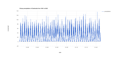 CHIRPS is an abbreviation for Climate Hazards Group InfraRed Precipitation with Station Data (Version 2.0 final). The CHIRPS is a 30+ year quasi-global rainfall dataset and inco...
-
Booklet on natural resources and wildlife status in protected areas and northern biodiversity corridor, north Tonle Sap lake 2020
Cambodia
Books and book chapters
Seng Kim Hout, Ministry of Environment
2020
This booklet provides a useful source of information and related data on the status of wildlife presence, habitats, natural resources, protected area commu...