-
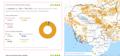
Tree cover loss by dominant driver

 ກຳປູເຈຍ
10 ເມສາ 2026
ແຫຼ່ງຂໍ້ມູນ: Global Forest Watch:...
ກຳປູເຈຍ
10 ເມສາ 2026
ແຫຼ່ງຂໍ້ມູນ: Global Forest Watch:...
ບໍ່ມີຄຳອະທິບາຍສຳລັບຊຸດຂໍ້ມູນນີ້
-
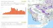
Forest-related greenhouse gas emissions in Cambodia
ກຳປູເຈຍ
9 ເມສາ 2026
ແຫຼ່ງຂໍ້ມູນ: Global Forest Watch:...
ບໍ່ມີຄຳອະທິບາຍສຳລັບຊຸດຂໍ້ມູນນີ້
-
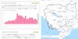
Plantations in Cambodia by provincial level
ກຳປູເຈຍ
8 ເມສາ 2026
ແຫຼ່ງຂໍ້ມູນ: Global Forest Watch:...

ບໍ່ມີຄຳອະທິບາຍສຳລັບຊຸດຂໍ້ມູນນີ້
-
Tree cover by land cover class in Cambodia 2020
ກຳປູເຈຍ
8 ເມສາ 2026
ແຫຼ່ງຂໍ້ມູນ: Global Forest Watch: https://gfw.global/LCQlwv

ບໍ່ມີຄຳອະທິບາຍສຳລັບຊຸດຂໍ້ມູນນີ້
-
Forest cover loss from fire
ກຳປູເຈຍ
6 ເມສາ 2026
ແຫຼ່ງຂໍ້ມູນ: Global Forest Watch:...
ບໍ່ມີຄຳອະທິບາຍສຳລັບຊຸດຂໍ້ມູນນີ້
-
Forest cover data
ກຳປູເຈຍ
28 ມັງກອນ 2026
ແຫຼ່ງຂໍ້ມູນ: Global Forest Watch:...

ບໍ່ມີຄຳອະທິບາຍສຳລັບຊຸດຂໍ້ມູນນີ້
-
National Forest Programme 2010-2029
ກຳປູເຈຍ
Issue and policy briefs
Ministry of Agriculture, Forestry and Fisheries
2010
The goal of the National Forest Programme is to establish a policy framework and strategy for sustainable management of the country’s valuable forest resources. This document,...
-
Forest cover in Cambodia (2015-2023)
ກຳປູເຈຍ
6 ກັນຍາ 2024
ແຫຼ່ງຂໍ້ມູນ: Servir SEA: https://cambodia-me-servir.adpc.net/mapviewer

ບໍ່ມີຄຳອະທິບາຍສຳລັບຊຸດຂໍ້ມູນນີ້
-
Land cover in Cambodia (2015-2023)
ກຳປູເຈຍ
21 ທັນວາ 2024
ແຫຼ່ງຂໍ້ມູນ: Servir SEA: https://cambodia-me-servir.adpc.net/mapviewer

ບໍ່ມີຄຳອະທິບາຍສຳລັບຊຸດຂໍ້ມູນນີ້
-
Sustainable Forest Management in Myanmar
ມຽນມາ
Conference/workshop proceedings and presentations
Thaung Naing Oo
2019
This power point presentation was presented at the Regional Workshop on “Enhancing Conservation and Sustainable Management of Teak Forests and Legal and Sustainable Wood Supply...
-
Assessing changes in mangrove forest cover and carbon stocks in the Lower Mekong Region using Google Earth Engine
ແມ່ຂອງ
Reports, journal articles, and research papers (including theses and dissertations)
Megha Bajaj, Nophea Sasaki, Takuji W. Tsusaka, Manjunatha...
2024
The Lower Mekong Region (LMR) faces significant loss of mangrove forests, yet limited studies have explored this decline in the region. Here, we employ Google Earth Engine and...
-
Over 380,000 acres of mangrove forests conserved in Rakhine State
ມຽນມາ
Archived web content
Global New Light Of Myanmar
2021
There are 381,036 acres of mangrove forest in Rakhine State, and six protected areas that cover 87,219 acres are state-owned.
-
Using satellite technology to monitor forest data
ກຳປູເຈຍ
Advocacy and promotional materials
YOUNG ECO
The podcast "Stream by Young Eco" is produced by Young Eco under the Civil Society Organization Support Project: the Fund for the Hub of Civil Society Organizations, supported...
-
Sub-decree no. 324 on the cutting of land from the forest cover in 2002 and the land reclassification of state public land into state private land covering 19,814 hectares, 78 ares and 40 centi-ares in Kaev Seima district, Kaoh Nheaek district, and Pech Chreada district, Mondulkiri province
ກຳປູເຈຍ
324
Sub-decree
7 ພະຈິກ 2023
This sub-decree shows the cutting of land from the forest cover in 2002 and the land reclassification of state public land into state private land covering 19,814 hectares, 78...
-
Sub-decree no. 64 on the cutting land of 60000 square meters, located in Krapeu village, Ballangk commune, Prasat Bakong district, Siemreap province from the forest cover 2002 to reclassify as state private land and grant ownership to national police school, region 4
ກຳປູເຈຍ
64
Sub-decree
3 ກັນຍາ 2023
This sub-decree aims to cut the land of 60000 square meters, located in Krapeu village, Ballangk commune, Prasat Bakong district, Siemreap province from the forest cover 2002...
-
Sub-decree no. 56 on the cutting land of 1 hectares 21 ares 61 centi-ares in Stung Hav district, Preah Sihanouk province from the forest cover 2002 to reclassify as state private and grant ownership to citizen
ກຳປູເຈຍ
56
Sub-decree
3 ມິຖຸນາ 2023
This sub-decree aims to cut the land of 1hectares 21 ares 61 centi-ares in Stung Hav district, Preah Sihanouk province from the forest cover 2002 to reclassify as state private...
-
Forest Monitoring by using Satellite System
ກຳປູເຈຍ
Conference/workshop proceedings and presentations
Mr. Bormy CHANTHONG
2023
This slide presentation shows the using of satellite systems for forest monitoring by Remote Sensing.
-
Land cover in Vietnam 2015 - 2018
 ຫວຽດນາມ
14 ກັນຍາ 2020
ແຫຼ່ງຂໍ້ມູນ: https://www.eorc.jaxa.jp
ຫວຽດນາມ
14 ກັນຍາ 2020
ແຫຼ່ງຂໍ້ມູນ: https://www.eorc.jaxa.jp
ບໍ່ມີຄຳອະທິບາຍສຳລັບຊຸດຂໍ້ມູນນີ້
-
The second science talk on the topic of "Carbon Credit"
ກຳປູເຈຍ
Conference/workshop proceedings and presentations
Olly Griffin, Wildlife Conservation Society
2023
This slide presentation focus on Carbon credit for the event of Science talk. The event provides an opportunity for participants from media institutions, universities,...
-
The third Science talk on "National forest monitoring system and forest inventory"
ກຳປູເຈຍ
Conference/workshop proceedings and presentations
This slide presentation focus on National Forest Monitoring System and Forest Inventory for the event of Science talk. The event provides an opportunity for participants from...