-
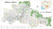
Environmental impact assessments

 กัมพูชา
30 พฤษภาคม ค.ศ. 2025
แหล่งข้อมูล: The Environmental Impact Assessment (EIA) reports were shared by...
กัมพูชา
30 พฤษภาคม ค.ศ. 2025
แหล่งข้อมูล: The Environmental Impact Assessment (EIA) reports were shared by...
ชุดข้อมูลไม่มีคำอธิบาย
-
Community forestry (2008-2017)
กัมพูชา
27 พฤศจิกายน ค.ศ. 2024
แหล่งข้อมูล: The reference sources were taken from Prakas from Ministry of...

ชุดข้อมูลไม่มีคำอธิบาย
-
Hydropower dam (1993-2020)
กัมพูชา
19 กรกฎาคม ค.ศ. 2024
แหล่งข้อมูล: JICA, Final Report on Data Collection Survey on Electric Power...

ชุดข้อมูลไม่มีคำอธิบาย
-
Cambodia atlas of gender and environment
กัมพูชา
2 มีนาคม ค.ศ. 2018
แหล่งข้อมูล: Cambodia atlas of gender and environment, The Asia Foundation
In 2017, the Asia Foundation initiated the “Atlas of Gender and Environment” project to provide a more in-depth understanding of how gender informs environment-related...
-
Geology of Cambodia (2006)
กัมพูชา
23 กันยายน ค.ศ. 2016
แหล่งข้อมูล: Save Cambodia's Wildlife. *Atlas of Cambodia: maps on...
 This dataset provides known locations of geolocial sites in Cambodia.Geographic data is encoded in the WGS 84 coordinate reference system. Data were provided to ODC in vector...
-
Population census 2019 (Provisional population totals)
กัมพูชา
27 กันยายน ค.ศ. 2021
แหล่งข้อมูล: Official website of National Institute of Statistics...

ชุดข้อมูลไม่มีคำอธิบาย
-
Cropland in Cambodia
กัมพูชา
2 สิงหาคม ค.ศ. 2019
แหล่งข้อมูล: Downloaded from WFPGeoNode:...
 This dataset contains information of cropland and location of croplands in Cambodia which was downloaded from World Food Programme GeoNode (WFPGeoNode) using data in 2013 from...
-
Forest cover in Cambodia (1973-2014)
กัมพูชา
25 พฤศจิกายน ค.ศ. 2015
แหล่งข้อมูล: U.S. Department of the Interior, United States Geological Survey...
 This dataset shows forest cover in Cambodia in 1973, 1989, 2000, 2004, 2009 and 2014. Geographic data is encoded in the WGS 84, Zone 48 North coordinate reference system. Data...
-
Indigenous people areas in Cambodia
กัมพูชา
4 ตุลาคม ค.ศ. 2015
แหล่งข้อมูล: A
 This vector dataset describes the areas where the indigenous communities were located in Cambodia. Dataset were provided to Open Development Cambodia (ODC) in vector format by...
-
Eviction and relocation hotspots in Cambodia (2013)
กัมพูชา
4 ตุลาคม ค.ศ. 2015
แหล่งข้อมูล: Sahmakum Teang Tnaut and Save Cambodia's Wildlife. Atlas of...
 This asset provides the area of eviction hotspots and relocation hotspots in Cambodia, with raster value that demonstrates number of families affected, given by Sahmakum Teang...
-
Assessment of undiscovered copper resources in Cambodia
กัมพูชา
15 มีนาคม ค.ศ. 2017
แหล่งข้อมูล: Zürcher, Lukas, Bookstrom, A.A., Hammarstrom, J.M., Mars, J.C.,...
 Deposits, prospects, and permissive tracts for porphyry and sediment-hosted copper resources Cambodia, with estimates of undiscovered copper resources. Copper resources are...
-
Wetlands in Cambodia
กัมพูชา
29 กรกฎาคม ค.ศ. 2019
แหล่งข้อมูล: Downloaded from...
 This dataset contains information of land areas and location of wetlands in Cambodia which was downloaded from World Food Programme GeoNode (WFPGeoNode) using data in 2013 from...
-
NGOs working on land tenure and titling issues in Cambodia
กัมพูชา
Reports, journal articles, and research papers (including theses and dissertations)
Open Development Cambodia
2015
A list of some NGOs working on land tenure and titling issues in Cambodia. Though Open Development Cambodia attempted to make this list as comprehensive as possible, the list...
-
Directive 01BB in Ratanakiri Province, Cambodia: Issues and Impacts of Private Land Titling in Indigenous Communities
กัมพูชา
Case studies
Rabe, Alison, SVC, NTFP, HA, CLEC and WHH
2013
To assess the impact of this new directive and its effects on the relationship between communal land titling and Economic Land Concessions (ELCs) in Ratanakiri, seven NGOs...
-
Hydropower in Cambodia: Competing discursive story-lines of a contested development path
กัมพูชา
Advocacy and promotional materials
Johannes Nilsson
2015
This thesis uses discourse to analyze how different story-lines of hydropower development in the Mekong River Basin reproduce the concept of sustainable development. With actors...
-
Pursat communal land use planning (CLUP) atlas 2009
กัมพูชา
18 เมษายน ค.ศ. 2017
แหล่งข้อมูล: Ministry of Land Management, Urban Planning and Construction...
 Pursat communal land use planning(CLUP) atlas (Chamraeun Phal, Kbal Trach, Me Tuek, Phteah Rung, Prongil, Roleab, Ta Lou, Tnaot Chum commune) is communal land use planning...
-
Koh Kong communal land use planning (CLUP) atlas 2009
กัมพูชา
18 เมษายน ค.ศ. 2017
แหล่งข้อมูล: Ministry of Land Management, Urban Planning and Construction...
 Koh Kong communal land use planning(CLUP) atlas (Andong Tuek, Chrouy Pras, Smach Mean Chey, Stung Veng, Tma Sa, and Trapeang Rung commune) is communal land use planning...
-
Siem Reap communal land use planning (CLUP) atlas 2009
กัมพูชา
18 เมษายน ค.ศ. 2017
แหล่งข้อมูล: Ministry of Land Management, Urban Planning and Construction...
 Siem Reap communal land use planning(CLUP) atlas (Chan Sar, Doun Peaeng, Leang Dai, Nokor Pheas , Popel, Srae Khvav, Svay Chek, Tayaek commune) is communal land use planning...
-
Kampong Speu commune land use planning (CLUP) atlas 2009
กัมพูชา
29 มีนาคม ค.ศ. 2017
แหล่งข้อมูล: Ministry of Land Management, Urban Planning and Construction...
Kampong Speu commune land use planning(CLUP) atlas (Kiri Vaon, Moha Sang, Honorom, Prabei Mom, Prey Khmeng, and Yea Angk commune) is communal land use planning extracted from...
-
Kampong Cham communal land use planning (CLUP) atlas 2009
กัมพูชา
18 เมษายน ค.ศ. 2017
แหล่งข้อมูล: Ministry of Land Management, Urban Planning and Construction...
 Kampong Cham communal land use planning(CLUP) atlas (Chikor, Moung Riev, Roang, and Srak commune) is communal land use planning extracted from 2009 contained both detailed...