-
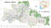
Kampong Speu commune land use planning (CLUP) atlas 2009
 Cambodia
29 tháng 3, 2017
Nguồn: Ministry of Land Management, Urban Planning and Construction...
Kampong Speu commune land use planning(CLUP) atlas (Kiri Vaon, Moha Sang, Honorom, Prabei Mom, Prey Khmeng, and Yea Angk commune) is communal land use planning extracted from...
Cambodia
29 tháng 3, 2017
Nguồn: Ministry of Land Management, Urban Planning and Construction...
Kampong Speu commune land use planning(CLUP) atlas (Kiri Vaon, Moha Sang, Honorom, Prabei Mom, Prey Khmeng, and Yea Angk commune) is communal land use planning extracted from...
-
Kampong Cham communal land use planning (CLUP) atlas 2009
Cambodia
18 tháng 4, 2017
Nguồn: Ministry of Land Management, Urban Planning and Construction...
 Kampong Cham communal land use planning(CLUP) atlas (Chikor, Moung Riev, Roang, and Srak commune) is communal land use planning extracted from 2009 contained both detailed...
-
Kết quả thống kê đất đai năm 2018 và 2019 tại Việt Nam
 Viet Nam
22 tháng 10, 2021
Nguồn: https://monre.gov.vn/Pages/phe-duyet-va-cong-bo-ket-qua-kiem-ke-die...
Bộ dữ liệu này là kết quả thống kê đất đai năm 2018 và năm 2019 của Bộ Tài nguyên và Môi trường Việt Nam. Kết quả thống kê năm 2018 với tổng diện tích đất tự nhiên là 33.123.597...
Viet Nam
22 tháng 10, 2021
Nguồn: https://monre.gov.vn/Pages/phe-duyet-va-cong-bo-ket-qua-kiem-ke-die...
Bộ dữ liệu này là kết quả thống kê đất đai năm 2018 và năm 2019 của Bộ Tài nguyên và Môi trường Việt Nam. Kết quả thống kê năm 2018 với tổng diện tích đất tự nhiên là 33.123.597...
-
Dataset on Plastic Waste in LMCs (Jambeck)
Cambodia, Myanmar, Thailand, Viet Nam
6 tháng 8, 2018
Nguồn: Jambeck, J. 2015. Plastic waste inputs from land into the ocean,...
Dataset from Jambeck Research Group on plastic waste, including only Lower Mekong Countries.
-
Laws and regulations on investment of the Kingdom of Cambodia
 Cambodia
10 tháng 1, 2023
Nguồn:
Cambodia
10 tháng 1, 2023
Nguồn:
Dữ liệu này không có mô tả
-
Baseline survey on mine/ERW (2009-2014)
Cambodia
2 tháng 4, 2020
Nguồn: Office for the Coordination of Humanitarian Affairs (OCHA) in Asia...
 This baseline survey data shows information about contamination locations of explosive remnants of war (ERW) and mines from 2009 to 2014. The data also included fear levels,...
-
Bộ dữ liệu về các loại rừng, quản lý và điều hành rừng ở Việt Nam
Viet Nam
2 tháng 11, 2022
Nguồn: http://www.terra-i.org/terra-i/data/data-terra-i_vietnam.html
Bộ dữ liệu nhằm thể hiện vị trí và thông tin các phát hiện biến động lớp phủ bề mặt đất. Dữ liệu này là kết quả dự án hợp tác giữa chương trình UN-REDD Việt Nam giai đoạn II và ...
-
CAIT - Historical Emissions Data (Countries, U.S. States, UNFCCC)
Brunei Darussalam, Cambodia, China, Christmas Island, Cocos (Keeling) Islands, Timor-Leste, Hong Kong, India, Indonesia, Japan, Korea (Democratic People's Republic of), Korea, Republic of, Lao People's Democratic Republic, Malaysia, Mongolia, Myanmar, Philippines, Singapore, Sri Lanka, Thailand, Viet Nam
7 tháng 2, 2018
Nguồn: CAIT Climate Data...
CAIT Historic allows for easy access, analysis and visualization of the latest available international greenhouse gas emissions data. It includes information for 191 countries...
-
Forest cover in Cambodia (2015-2018)
Cambodia
13 tháng 6, 2018
Nguồn: The forest monitoring system which is the product of collaboration...
 This forest cover is extracted from the Forest Monitoring System (https://rlcms-servir.adpc.net/en/forest-monitor/) which is developed by SERVIR-Mekong and the Global Land...
-
-
Environmental impact assessments
Cambodia
30 tháng 5, 2025
Nguồn: The Environmental Impact Assessment (EIA) reports were shared by...
Dữ liệu này không có mô tả
-
Geology of Cambodia (2006)
Cambodia
23 tháng 9, 2016
Nguồn: Save Cambodia's Wildlife. *Atlas of Cambodia: maps on...
 This dataset provides known locations of geolocial sites in Cambodia.Geographic data is encoded in the WGS 84 coordinate reference system. Data were provided to ODC in vector...
-
Basic map of Cambodia (2014)
Cambodia
4 tháng 12, 2023
Nguồn: Office for the Coordination of Humanitarian Affairs stores the...

Dữ liệu này không có mô tả
-
Forest cover in Cambodia (1973-2014)
Cambodia
25 tháng 11, 2015
Nguồn: U.S. Department of the Interior, United States Geological Survey...
 This dataset shows forest cover in Cambodia in 1973, 1989, 2000, 2004, 2009 and 2014. Geographic data is encoded in the WGS 84, Zone 48 North coordinate reference system. Data...
-
Practicing lawyers, Lower Mekong
Cambodia, Viet Nam, Lao People's Democratic Republic, Thailand, Myanmar
31 tháng 5, 2016
Nguồn: Cambodia: B Dunlap. The Rule of Law Without Lawyers: American...
The number of practicing lawyers in each Lower Mekong country, from various sources. Collated for a visualization on the OD Mekong Law and judiciary page...
-
Prison statistics for Lower Mekong
Cambodia, Viet Nam, Lao People's Democratic Republic, Thailand, Myanmar
31 tháng 5, 2016
Nguồn: International Centre for Prison Studies. World Prison Brief....
Data from the International Centre for Prison Studies, World Prison Brief, showing number of prisons, inmates and capacity in Lower Mekong countries. Collated for a...
-
Doing Business Report 2016, Lower Mekong
Cambodia, Viet Nam, Lao People's Democratic Republic, Thailand, Myanmar
31 tháng 5, 2016
Nguồn: World Bank Doing Business Report, 2016,...
The Lower Mekong scores for the World Bank's 2016 Doing Business Report. Collated for a visualization on the OD Mekong Law and judiciary page...
-
Thailand industrial estates
Thailand
21 tháng 6, 2016
Nguồn: Industrial Estate Authority of Thailand....
Data taken from the IEAT on all industrial estates in Thailand as of 2015. Used on the OD Mekong Thailand Land page: https://opendevelopmentmekong.net/topics/land-thailand
-
LandScan dataset 2012, Oak Ridge National Laboratory (ORNL) Prod2
 Myanmar
21 tháng 5, 2019
Nguồn: Oak Ridge National Laboratory (ORNL) LandScan dataset
Data on estimation of population in 2012 (before the Census 2014 existed) from the Oak Ridge National Laboratory (ORNL) LandScan dataset.
Myanmar
21 tháng 5, 2019
Nguồn: Oak Ridge National Laboratory (ORNL) LandScan dataset
Data on estimation of population in 2012 (before the Census 2014 existed) from the Oak Ridge National Laboratory (ORNL) LandScan dataset.
-
Các khu kinh tế tại các tỉnh của Việt Nam
Viet Nam
21 tháng 6, 2016
Nguồn: UNIDO. Economic zones in the ASEAN....
 Một số khu công nghiệp và khu kinh tế ở mỗi tỉnh của Việt Nam, dựa trên một bản đồ từ Bộ Kế hoạch và Đầu tư được nêu trong báo cáo của UNIDO. Đối chiếu với bản đồ trên trang OD...

You can also access this registry using the Giao diện lập trình ứng dụng (see Văn bản API).