-
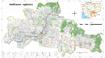
Land cover in Cambodia (2015-2023)
 Cambodia
June 11, 2024
Source:
Cambodia
June 11, 2024
Source:
 The Cambodia national Land Cover time series (2015-2023) was derived from the Biophysical M&E Dashboard tool, being used by USAID/Cambodia to track performance and report on lan...
-
State land reclassification
 Cambodia
February 19, 2024
Source: Royal Gazettes of Cambodia
Cambodia
February 19, 2024
Source: Royal Gazettes of Cambodia
 This dataset contains information regarding the establishment of land as state public property and the reclassification to state private property of some areas in Phnom Penh, Ka...
-
Eviction and relocation hotspots in Cambodia (2013)
Cambodia
October 4, 2015
Source: Sahmakum Teang Tnaut and Save Cambodia's Wildlife. Atlas of...
 This asset provides the area of eviction hotspots and relocation hotspots in Cambodia, with raster value that demonstrates number of families affected, given by Sahmakum Teang T...
-
Systematic land registration in Cambodia (2013)
Cambodia
October 4, 15
Source: Ministry of Land Management, Urban Planning and Construction. Land...
 This dataset describes the status of systematic land registration in Cambodia's communes by March 2013, as given in the Cambodian Ministry of Land Management's Land Administrati...
-
Pursat communal land use planning (CLUP) atlas 2009
Cambodia
April 18, 2017
Source: Ministry of Land Management, Urban Planning and Construction...
 Pursat communal land use planning(CLUP) atlas (Chamraeun Phal, Kbal Trach, Me Tuek, Phteah Rung, Prongil, Roleab, Ta Lou, Tnaot Chum commune) is communal land use planning extra...
-
Koh Kong communal land use planning (CLUP) atlas 2009
Cambodia
April 18, 2017
Source: Ministry of Land Management, Urban Planning and Construction...
 Koh Kong communal land use planning(CLUP) atlas (Andong Tuek, Chrouy Pras, Smach Mean Chey, Stung Veng, Tma Sa, and Trapeang Rung commune) is communal land use planning extracte...
-
Ratanakiri communal land use planning (CLUP) atlas 2009
Cambodia
April 18, 2017
Source: Ministry of Land Management, Urban Planning and Construction...
 Ratanakiri communal land use planning(CLUP) atlas (Aekakpheap, Ka Choun, Pong, Sameaki, Serei Mongkol, and Toen commune) is communal land use planning extracted from 2009 contai...
-
Siem Reap communal land use planning (CLUP) atlas 2009
Cambodia
April 18, 2017
Source: Ministry of Land Management, Urban Planning and Construction...
 Siem Reap communal land use planning(CLUP) atlas (Chan Sar, Doun Peaeng, Leang Dai, Nokor Pheas , Popel, Srae Khvav, Svay Chek, Tayaek commune) is communal land use planning ext...
-
Kampong Cham communal land use planning (CLUP) atlas 2009
Cambodia
April 18, 2017
Source: Ministry of Land Management, Urban Planning and Construction...
 Kampong Cham communal land use planning(CLUP) atlas (Chikor, Moung Riev, Roang, and Srak commune) is communal land use planning extracted from 2009 contained both detailed curre...
-
Mondulkiri communal land use planning (CLUP) atlas 2009
Cambodia
April 18, 2017
Source: Ministry of Land Management, Urban Planning and Construction...
 Mondulkiri communal land use planning(CLUP) atlas (Dak Dam, Pu Chri, Saen Monourom, Srae Ampum, Srae Khtum, and Srae Preah commune) is communal land use planning extracted from ...
-
Kratie communal land use planning (CLUP) atlas 2009
Cambodia
April 18, 2017
Source: Ministry of Land Management, Urban Planning and Construction...
 Kratie communal land use planning(CLUP) atlas (Dar, Kbal Damrey, O Krieng, Ruessei Kaev, Saob, Srae Char, Svay Chreah, and Thmi commune) is communal land use planning extracted ...