| အချက်အလက်အစု ခေါင်းစဉ်အမျိုးအစား |
Social development |
| ဘာသာစကား |
- အင်္ဂလိပ်ဘာသာစကား
- ခမာဘာသာစကား
|
| အသုံးပြုခြင်းဆိုင်ရာ အကန့်အသတ်များ |
By accessing this website or database, users agree to take full responsibility for reliance on any site information provided and to hold harmless and waive any and all liability against individuals or entities associated with its development, form and content for any loss, harm or damage suffered as a result of its use.
|
| အချက်အလက်အစုကို ရည်ညွှန်းသောရက်စွဲ |
2017၊ 3 အောက်တိုဘာ
|
| ဘူမိအမည်များ |
|
| သတ်မှတ်ဧရိယာ၏ အနောက်ဘက် ကိုဩဒိနိတ် |
102.64262769296215 |
| သတ်မှတ်ဧရိယာ၏ အရှေ့ဘက် ကိုဩဒိနိတ် |
107.57496972569096 |
| သတ်မှတ်ဧရိယာ၏ တောင်ဘက် ကိုဩဒိနိတ် |
10.685191238951724 |
| သတ်မှတ်ဧရိယာ၏ မြောက်ဘက် ကိုဩဒိနိတ် |
14.446790553237067 |
| နေရာဆိုင်ရာ ရည်ညွှန်းစနစ် |
WGS 84 / UTM zone 48N (EPSG:32648) |
| ကျိုးကြောင်းဆီလျော်မှုရှိ၊ မရှိ |
There are no known issues with accuracy.
|
| ပြည့်စုံမှု |
This dataset contains all of the data that is currently available to Open Development Cambodia (ODC) and is not exhaustive. While ODC takes every efforts to ensure that both spatial and non-spatial data are accurate and up to date. Moreover, additional SLCs, which are not yet included here, may have been approved and established.
|
| ဖြစ်စဉ် |
Available data was collected from many sources by ODC’s mappers such as the royal gazette of Cambodia's government, and Worldbank website in hard and soft copies of pdf format. The data in pdf format was then transformed into Shapefile, and CSV format then transformed to SQLITE format. When the map is not available in the sources, the data is digitized by based on the location stated in the source. The data in SQLITE format was finally exported to DB_TABLE, and WMS that can download as KML, Shapefile, and GeoJSON files.
|
| ရင်းမြစ်များ |
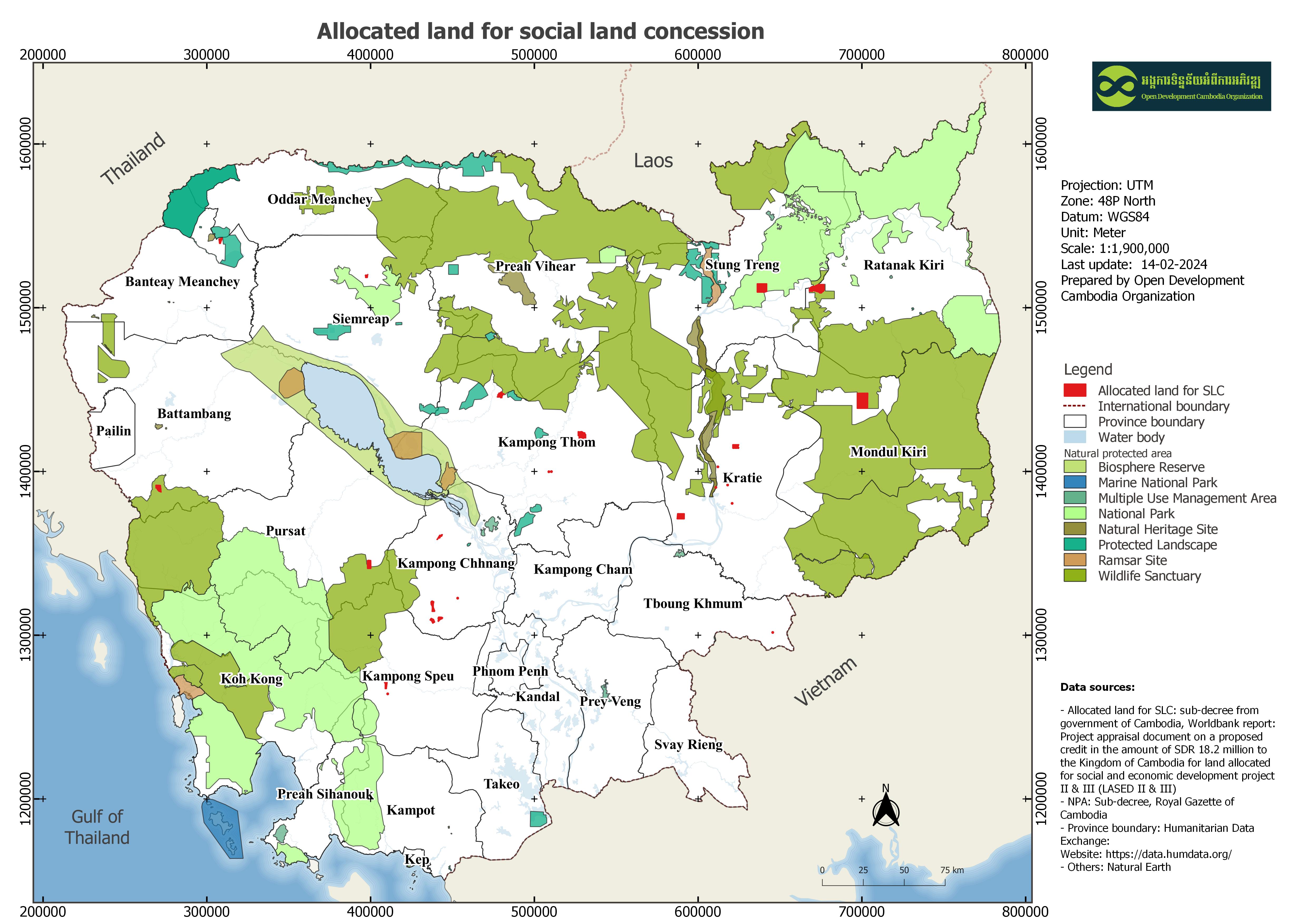
World Bank Publication: Project appraisal document on a proposed credit in the amount of SDR 18.2 million to the Kingdom of Cambodia for land allocation for social and economic development project II (LASED II)
|
| တာဝန်ရှိသော အဖွဲ့အစည်း |
World Bank Country Office Exchange Square Building, No. 19-20, Street 106, Sangkat Wat Phnom, Khan Daun Penh, Phnom Penh Tel: +855 23 261300 Fax: + 855 23 261301-2 cambodia@worldbank.org
|
| Metadata ကို ဖန်တီးသူ၏ သတင်းအချက်အလက် |
Metadata last updated on 2022-05-31. For inquiries contact: Open Development Cambodia Address: #23B St. 606, Phnom Penh, Cambodia. Email: contact@opendevcam.net Website: http://www.opendevcam.net
|
| ၀ိသေသများ |
map_id;Province;District;Commune;village/site;Total Land Distribute_ H ;Agriculture Land Distribute_HA;Land Recipients;Population Women Population;Last Project;Last Project; Closing date;Current project;Current Project ;Closing date;Status;Reference;language
|
| ခွင့်ပြုချက် |
Creative Commons Attribution
|
| မူပိုင်ခွင့် |
Yes |
| ပြင်ဆင်ချက် |
1.0 |
| နယ်ပယ် |
- Kampong Cham
- Kampong Chhnang
- Kampong Speu
- Kratie
- Mondulkiri
- Pursat
- Stung Treng
- Ratanakiri
- Banteay Meanchey
- Battambang
- Tboung Khmum
|
| အဓိကစကားလုံးများ |
Social land concession,Land Allocation for Social and Economic Development (LASED),LASED |
| တင်ခဲ့သည့်ရက်စွဲ |
အောက်တိုဘာ 3, 2017, 04:13 (UTC)
|
| ပြန်လည်ပြင်ဆင်သည့်ရက်စွဲ |
ဖေဖော်ဝါရီ 3, 2026, 03:38 (UTC)
|