| အချက်အလက်အစု ခေါင်းစဉ်အမျိုးအစား |
- Access to education
- Primary and secondary education
- Social development
|
| ဘာသာစကား |
|
| အသုံးပြုခြင်းဆိုင်ရာ အကန့်အသတ်များ |
By accessing this website or database, users agree to take full responsibility for reliance on any site information provided and to hold harmless and waive any and all liability against individuals or entities associated with its development, form and content for any loss, harm or damage suffered as a result of its use.
|
| အချက်အလက်အစုကို ရည်ညွှန်းသောရက်စွဲ |
2013၊ 1 အောက်တိုဘာ
|
| ဘူမိအမည်များ |
|
| သတ်မှတ်ဧရိယာ၏ အနောက်ဘက် ကိုဩဒိနိတ် |
102.33526428297924 |
| သတ်မှတ်ဧရိယာ၏ အရှေ့ဘက် ကိုဩဒိနိတ် |
107.56402636380297 |
| သတ်မှတ်ဧရိယာ၏ တောင်ဘက် ကိုဩဒိနိတ် |
10.419519523759812 |
| သတ်မှတ်ဧရိယာ၏ မြောက်ဘက် ကိုဩဒိနိတ် |
14.435511197121683 |
| နေရာဆိုင်ရာ ရည်ညွှန်းစနစ် |
WGS 84 / UTM zone 48N (EPSG:32648) |
| အနေအထား တိကျမှန်ကန်မှု |
There are no known issues with accuracy.
|
| ကျိုးကြောင်းဆီလျော်မှုရှိ၊ မရှိ |
There are no known issues with logical consistency.
|
| ပြည့်စုံမှု |
There are no known issues with completeness.
|
| ဖြစ်စဉ် |
Data were provided to Open Development Cambodia directly by Save Cambodia's Wildlife's 2013 Atlas Working Group in ESRI Shapefile format. The coordinate reference system was changed from WGS 84 Zone 48 N to WGS 84 and the data was exported in both ESRI Shapefile, geoJSON and CSV formats.
|
| ရင်းမြစ်များ |
Ministry of Education, Youth and Sports, Royal Government of Cambodia. Inventory and Location of Schools in Cambodia. Phnom Penh, 2013.
Save Cambodia's Wildlife. "Education." Atlas of Cambodia: maps on socio-economic development and environment. Second ed. Phnom Penh, 2014. 72. Print.
|
| တာဝန်ရှိသော အဖွဲ့အစည်း |
Save Cambodia's Wildlife (SCW), info@cambodiaswildlife.org, +855 23 88 20 35, http://cambodiaswildlife.org, 6Eo St. 570, Sangkat Boeung Kak 2, Khan Tuol Kork, Phnom Penh, Cambodia.
|
| Metadata ကို ဖန်တီးသူ၏ သတင်းအချက်အလက် |
Metadata last updated on 2014-06-26. For inquiries contact: Open Development Cambodia, contact@opendevcam.net, +855 23 221 164, http://www.opendevelopmentcambodia.net, 43 St. 208, Sangkat Boeung Riang, Khan Daun Penh, Phnom Penh, Cambodia.
|
| ၀ိသေသများ |
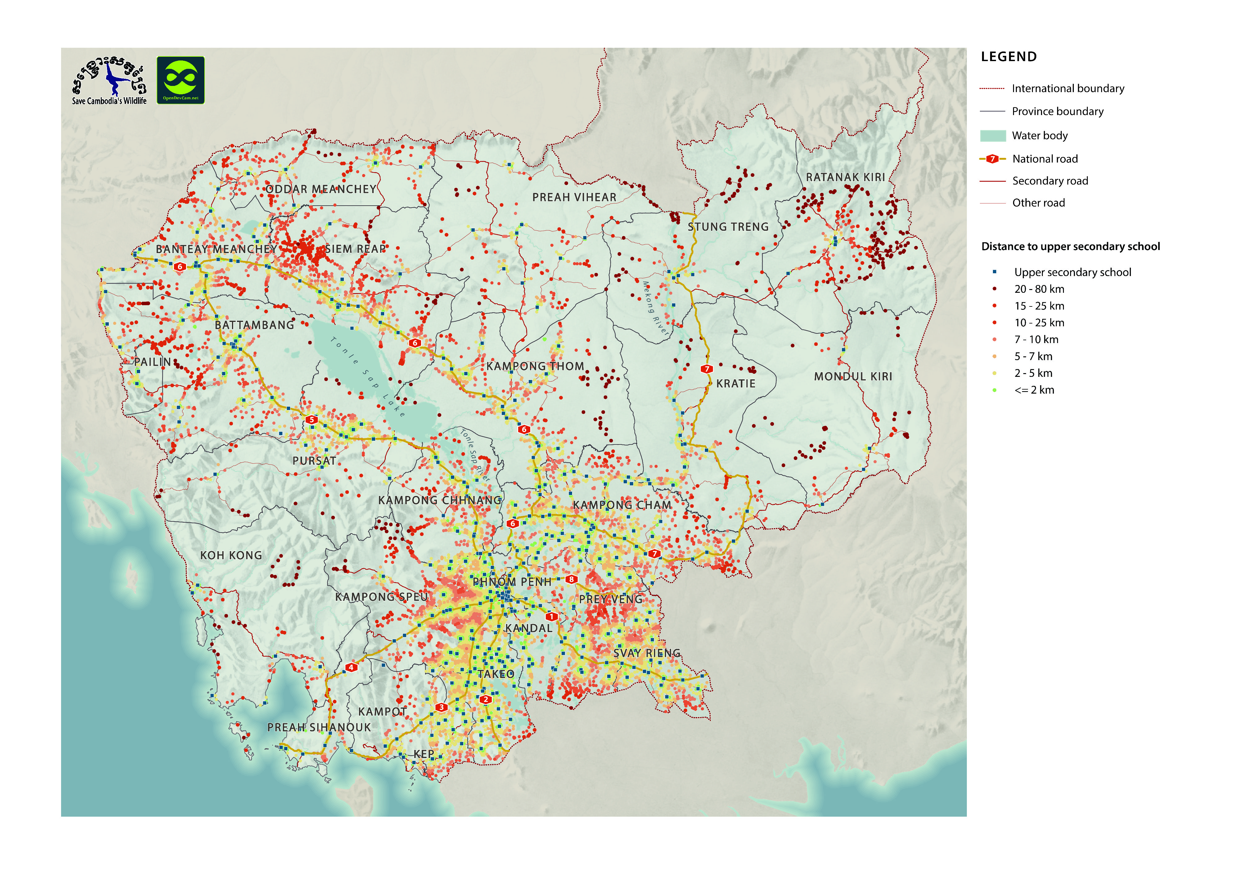
Longitude / Government of Cambodia: Longitude of village, Latitude / Government of Cambodia: Latitude of village, Vil_Code / Government of Cambodia: Village Code, Village / Government of Cambodia: Village Name, School_Name / Government of Cambodia: Name of Secondary School, School_Dist / Government of Cambodia: Distance from Secondary School.
|
| ခွင့်ပြုချက် |
CC-BY-SA-4.0
|
| မူပိုင်ခွင့် |
Yes |
| ပြင်ဆင်ချက် |
1.0 |
| အဓိကစကားလုံးများ |
school |
| တင်ခဲ့သည့်ရက်စွဲ |
အောက်တိုဘာ 4, 2015, 21:01 (UTC)
|
| ပြန်လည်ပြင်ဆင်သည့်ရက်စွဲ |
အောက်တိုဘာ 8, 2019, 18:42 (UTC)
|