Building footprints in Phnom Penh
พิมพ์โดย: Open Development Cambodia
ทรัพยากรข้อมูล (7)
ตัวอย่างทรัพยากรข้อมูล - Building footprints in Phnom Penh
ข้อมูลเพิ่มเติม
| ฟิลด์ | ค่า |
|---|---|
| หมวดหมู่หัวข้อของชุดข้อมูล |
|
| ภาษา |
|
| ข้อจำกัดการใช้งาน | By accessing this website OD Mekong website and database users agree to take full responsibility for reliance on any site information provided and to hold harmless and waive any and all liability against individuals or entities associated with its development, form and content for any loss, harm or damage suffered as a result of its use. |
| วันที่ชุดข้อมูล | 1 พฤษภาคม ค.ศ. 2023 |
| ชื่อทางภูมิศาสตร์ |
|
| ระบบอ้างอิงเชิงพื้นที่ | WGS 84 / UTM zone 48N (EPSG:32648) |
| ความแม่นยำเชิงตำแหน่ง | The accuracy regarding to the Imagery completeness errors and detection error, estimated 80% and 90% precision levels. |
| ความแม่นยำของคุณสมบัติ | There are no known issues with attribute accuracy. |
| ความสอดคล้องเชิงตรรกะ | There are no known issues with logical consistency. |
| ความสมบูรณ์ | The dataset freshness is determined by the availability of the high-resolution source imagery which used to detect buildings. |
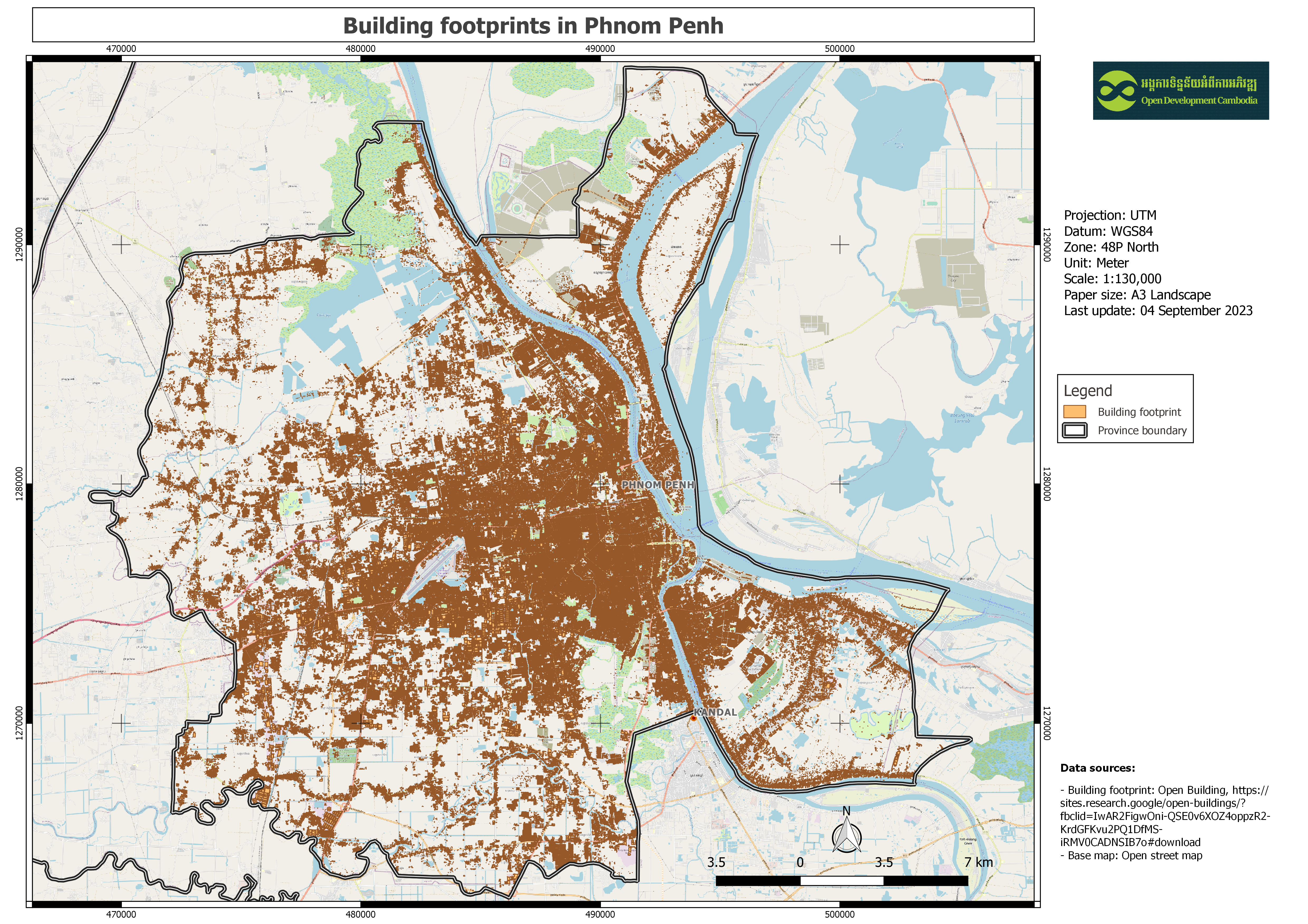
| ขั้นตอนของกระบวนการ | This dataset contains polygon data in CSV format that was manually downloaded for a single cell in the Cambodia region. Then, using the QGIS application, clip only the Phnom Penh border, export as geospatial data, and upload to the ODC website. |
| แหล่งที่มา | Òpen Building: https://sites.research.google/open-buildings/?fbclid=IwAR2FigwOni-QSE0v6XOZ4oppzR2-KrdGFKvu2PQ1DfMS-iRMV0CADNSIB7o#download |
| ฝ่ายงานรับผิดชอบ | W. Sirko, S. Kashubin, M. Ritter, A. Annkah, Y.S.E. Bouchareb, Y. Dauphin, D. Keysers, M. Neumann, M. Cisse, J.A. Quinn. Continental-scale building detection from high resolution satellite imagery. arXiv:2107.12283, 2021. |
| ข้อมูลผู้สร้างคำอธิบายชุดข้อมูล | Metadata last updated on 2020-04-09. For inquiries contact: Open Development Cambodia, Email: contact@opendevcam.net, Website: http://www.opendevcam.net Address: 43 St. 208, Phnom Penh, Cambodia |
| คุณสมบัติ | latitude: latitude of the building polygon centroid; longitude: longitude of the building polygon centroid; area_in_me: area in square meters of the polygon; confidence: confidence score [0.65;1.0] assigned by the model; geometry: the building polygon in the WKT format (POLYGON or MULTIPOLYGON); This feature is present in only in polygons data; full_plusc: the full Plus Code at the building polygon centroid |
| ความถี่ในการปรับปรุง | ไม่ทราบ |
| สัญญาอนุญาต | Creative Commons Attribution Share-Alike |
| ลิขสิทธิ์ | No |
| เวอร์ชัน | 3 |
| จังหวัด |
|
| คำสำคัญ | Building,Footprints |
| วันที่อัพโหลด | สิงหาคม 31, 2023, 02:12 (UTC) |
| แก้ไขเมื่อ | ตุลาคม 18, 2023, 07:58 (UTC) |