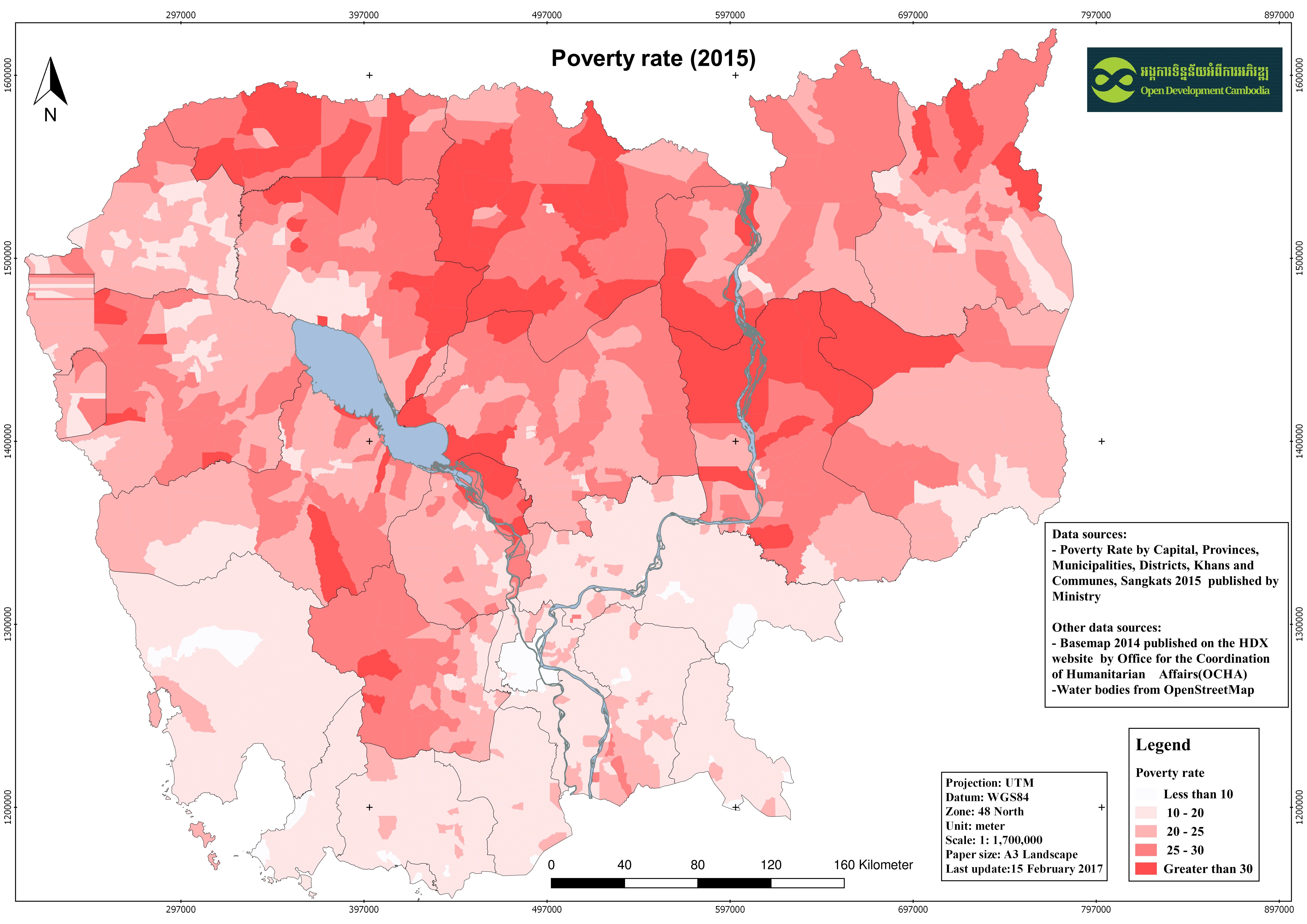
Cambodian population and poverty rate 2015
พิมพ์โดย: Open Development Cambodia
ทรัพยากรข้อมูล (7)
ตัวอย่างทรัพยากรข้อมูล - Cambodian population and poverty rate 2015
ข้อมูลเพิ่มเติม
| ฟิลด์ | ค่า |
|---|---|
| หมวดหมู่หัวข้อของชุดข้อมูล |
|
| ภาษา |
|
| ข้อจำกัดการใช้งาน | By accessing this website or database, users agree to take full responsibility for reliance on any site information provided and to hold harmless and waive any and all liability against individuals or entities associated with its development, form and content for any loss, harm or damage suffered as a result of its use. |
| วันที่ชุดข้อมูล | 23 มกราคม ค.ศ. 2017 |
| ชื่อทางภูมิศาสตร์ |
|
| พิกัดขอบเขตทิศตะวันตก | 102.32040017933838 |
| พิกัดขอบเขตทิศตะวันออก | 107.6427929109558 |
| พิกัดขอบเขตทิศใต้ | 10.34357826058839 |
| พิกัดขอบเขตทิศเหนือ | 14.704156340453409 |
| ระบบอ้างอิงเชิงพื้นที่ | WGS 84 / UTM zone 48N (EPSG:32648) |
| ความแม่นยำเชิงตำแหน่ง | There are no known about the issues of accuracy. |
| ความสอดคล้องเชิงตรรกะ | There are no known issues with logical consistency. |
| ความสมบูรณ์ | There are no known issues with completeness. |
| ขั้นตอนของกระบวนการ | ODC Map and Data team downloaded the non-spatial data from website of Ministry of Planning in PDF format then coveted and clean it to excel format as the attribute information for the shapefile. After that the excel file was join with the shapefile of Cambodia basemap 2014 which was published on Humanitarian Data Exchange (HDX). The result of the join was converted for various extension such as GeoJson, KML, JPEG, and spreadsheet |
| แหล่งที่มา | -Ministry of Planning of Cambodia: www.mop.gov.kh/ -Humanitarian Data Exchange (HDX): https://data.humdata.org |
| ฝ่ายงานรับผิดชอบ | For non-spatial data: - Ministry of Planning Address: 386 Monivong Boulevard, Phnom Penh Postal Code: 12302 Phone: 023 720 901 For spatial data: - Humanitarian Data Exchange (HDE) Email: hdx@un.org. Website: https://data.humdata.org/ |
| ข้อมูลผู้สร้างคำอธิบายชุดข้อมูล | Metadata last updated on 2017-01-23. For inquiries contact: Open Development Cambodia (ODC). Address: #43 St. 208, Sangkat Boeung Raing, Khan Daun Penh, Phnom Penh, Cambodia. Email: contact@opendevcam.net Website: https://opendevelopmentcambodia.net |
| คุณสมบัติ | tot_pop: total population;tot_family: total family;pov_rate:poverty rate |
| สัญญาอนุญาต | CC-BY-SA-4.0 |
| ลิขสิทธิ์ | Yes |
| เวอร์ชัน | 1.0 |
| วันที่อัพโหลด | มกราคม 23, 2017, 03:08 (UTC) |
| แก้ไขเมื่อ | มิถุนายน 11, 2020, 04:02 (UTC) |