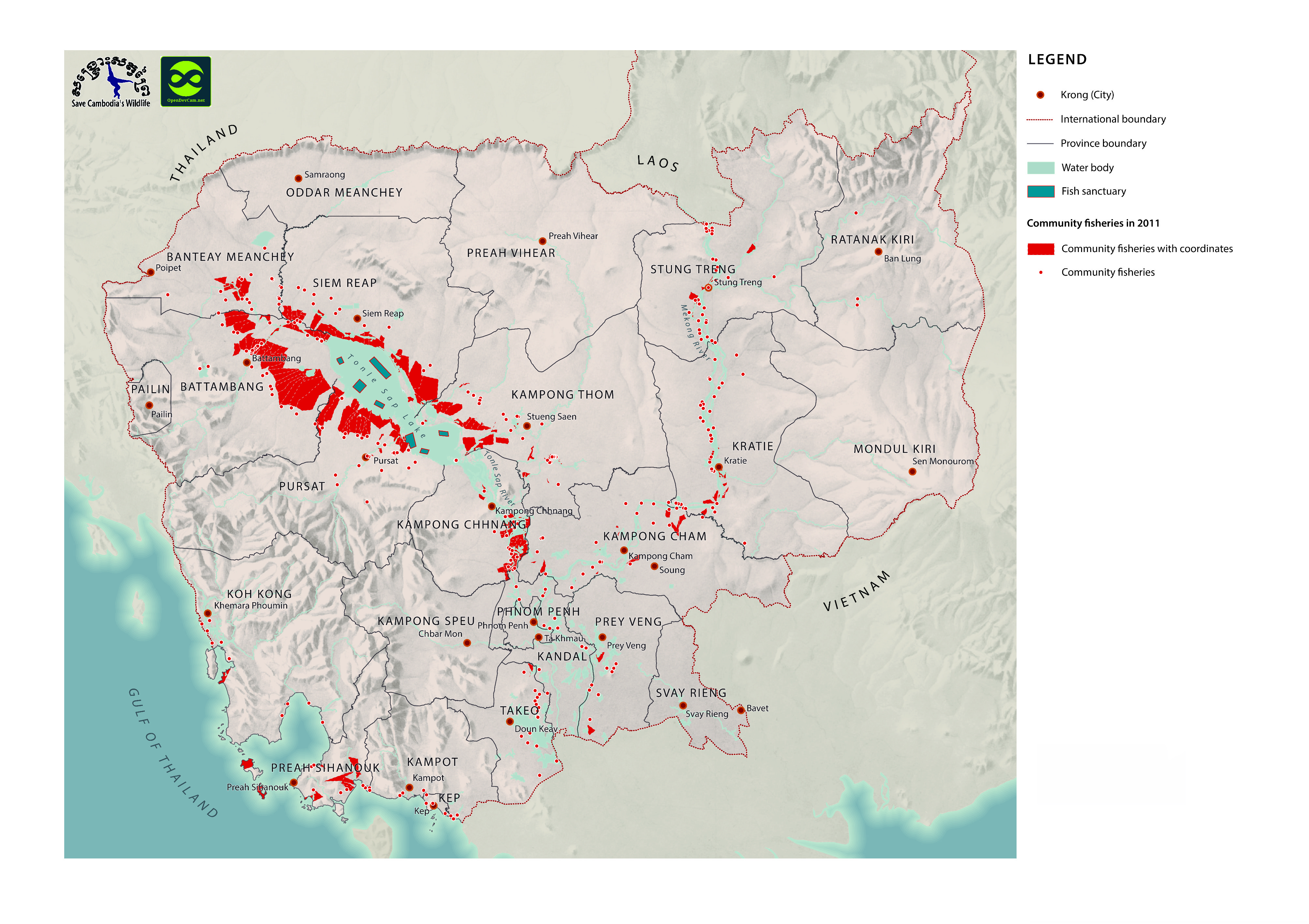
Community fisheries map for Cambodia (2011)
พิมพ์โดย: Open Development Cambodia
ทรัพยากรข้อมูล (6)
ตัวอย่างทรัพยากรข้อมูล - Community fisheries map for Cambodia (2011)
ข้อมูลเพิ่มเติม
| ฟิลด์ | ค่า |
|---|---|
| หมวดหมู่หัวข้อของชุดข้อมูล |
|
| ภาษา |
|
| วันที่ชุดข้อมูล | 1 พฤศจิกายน ค.ศ. 2011 |
| ชื่อทางภูมิศาสตร์ |
|
| พิกัดขอบเขตทิศตะวันตก | 102.9940845566991 |
| พิกัดขอบเขตทิศตะวันออก | 106.25913130336272 |
| พิกัดขอบเขตทิศใต้ | 10.504919839981296 |
| พิกัดขอบเขตทิศเหนือ | 13.934043680035312 |
| ระบบอ้างอิงเชิงพื้นที่ | WGS 84 / UTM zone 48N (EPSG:32648) |
| ความแม่นยำเชิงตำแหน่ง | A number of community fisheries are missing geographic coordinates and so are represented on the map as a point at their commune's center. |
| ความสอดคล้องเชิงตรรกะ | There are no known issues with logical consistency. |
| ความสมบูรณ์ | A number of community fisheries are missing geographic coordinates and so are represented on the map as a point at their commune's center. |
| ขั้นตอนของกระบวนการ | Data were provided to Open Development Cambodia directly by Save Cambodia's Wildlife's 2013 Atlas Working Group in ESRI Shapefile format. The coordinate reference system was changed from WGS 84 Zone 48 N to WGS 84 and the data was exported in geoJSON format. |
| แหล่งที่มา | Fisheries Administration. Phnom Penh, 2013. National Committee for Sub-National Democratic Development. Commune Database 2011. Phnom Penh, 2011.Save Cambodia's Wildlife. "Fish Resources." Atlas of Cambodia: maps on socio-economic development and environment. Second ed. Phnom Penh, 2014. 46-47. Print. |
| ฝ่ายงานรับผิดชอบ | Save Cambodia's Wildlife (SCW), info@cambodiaswildlife.org, +855 23 88 20 35, http://cambodiaswildlife.org, 6Eo St. 570, Sangkat Boeung Kak 2, Khan Tuol Kork, Phnom Penh, Cambodia |
| ข้อมูลผู้สร้างคำอธิบายชุดข้อมูล | Metadata last updated on 2014-06-19. For inquiries contact: Loch Kalyan, Open Development Cambodia, contact@opendevcam.net, +855 23 221 164, http://www.opendevelopmentcambodia.net, 43 St. 208, Sangkat Boeung Riang, Khan Daun Penh, Phnom Penh, Cambodia. |
| คุณสมบัติ | Code/Fisheries Administration: Code defined by the Fisheries Administration, Name/Fisheries Administration: Name of the fishery, Vil_Num/Fisheries Administration: Number of villages covered by the community fisheries, Province/Fisheries Administration: The province where the fishery is located, District/Fisheries Administration: The district where the fishery is located, Commune/Fisheries Administration: The commune where the fishery is located, LSize_Ha/Fisheries Administration: Size of the fishery (hectares) |
| สัญญาอนุญาต | CC-BY-4.0 |
| ลิขสิทธิ์ | No |
| เวอร์ชัน | 1.0 |
| คำสำคัญ | cfi |
| วันที่อัพโหลด | พฤศจิกายน 25, 2015, 18:55 (UTC) |
| แก้ไขเมื่อ | เมษายน 12, 2024, 07:07 (UTC) |