| หมวดหมู่หัวข้อของชุดข้อมูล |
- Community forest
- Environment and natural resources
- Non-timber forest products
|
| ภาษา |
|
| วันที่ชุดข้อมูล |
1 มกราคม ค.ศ. 2013
|
| ชื่อทางภูมิศาสตร์ |
|
| พิกัดขอบเขตทิศตะวันตก |
102.38394081749213 |
| พิกัดขอบเขตทิศตะวันออก |
107.45783325570238 |
| พิกัดขอบเขตทิศใต้ |
10.493195976418543 |
| พิกัดขอบเขตทิศเหนือ |
14.397960890673236 |
| ระบบอ้างอิงเชิงพื้นที่ |
WGS 84 / UTM zone 48N (EPSG:32648) |
| ความแม่นยำเชิงตำแหน่ง |
There are no known issues with accuracy.
|
| ความสอดคล้องเชิงตรรกะ |
There are no known issues with logical consistency.
|
| ความสมบูรณ์ |
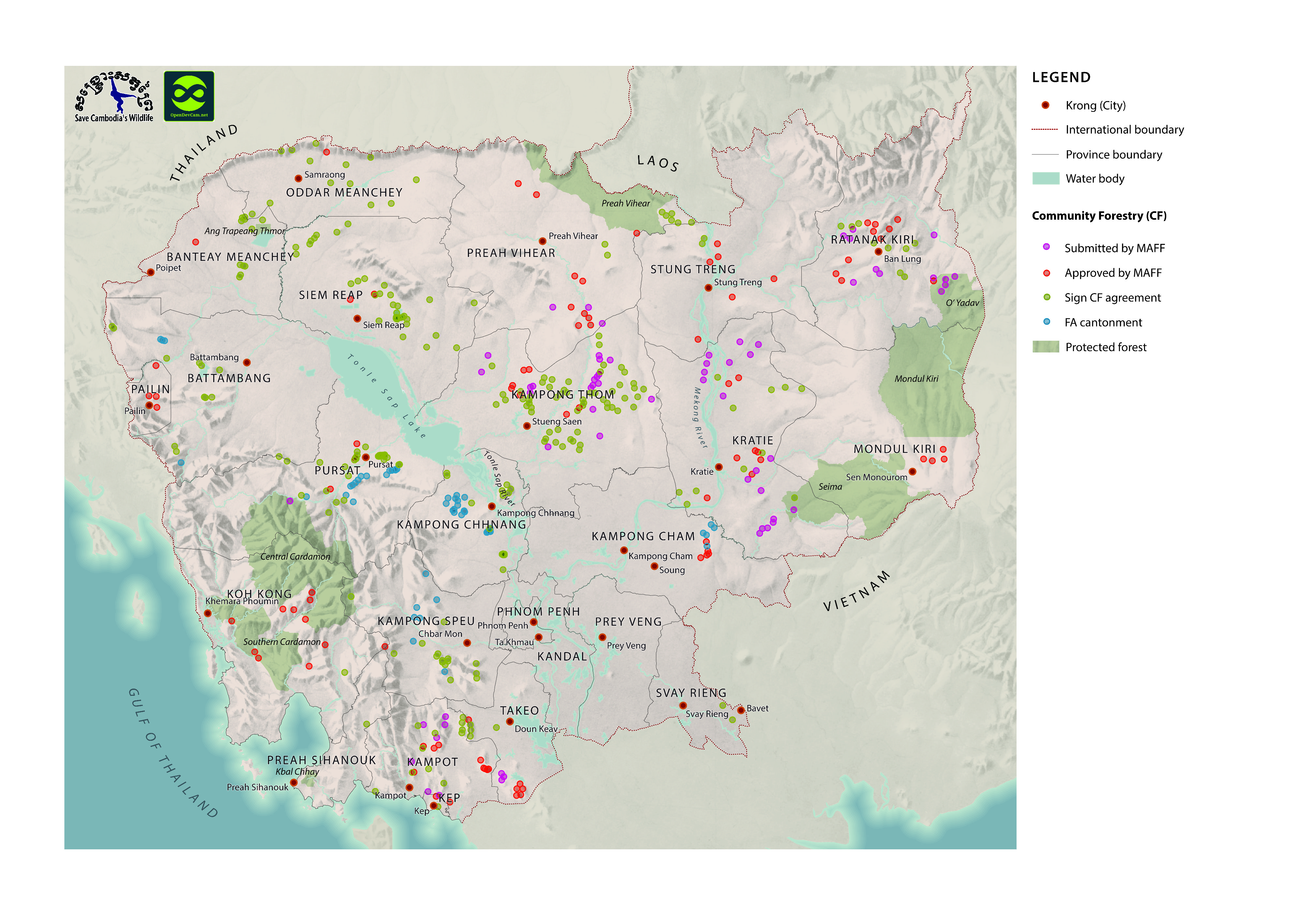
12 of the 460 actual and potential community forests in the dataset have their status marked as 'FA.' It is unclear what this means.
|
| ขั้นตอนของกระบวนการ |
Data were provided to Open Development Cambodia directly by Save Cambodia's Wildlife's 2013 Atlas Working Group in ESRI Shapefile format. The coordinate reference system was changed from WGS 84 Zone 48 N to WGS 84 and the data was exported in both ESRI Shapefile, geoJSON and CSV formats.
|
| แหล่งที่มา |
Forestry Administration, Government of Cambodia. Phnom Penh, 2013.Save Cambodia's Wildlife. "Forests." Atlas of Cambodia: maps on socio-economic development and environment. Second ed. Phnom Penh, 2014. 16-18. Print.
|
| ฝ่ายงานรับผิดชอบ |
Save Cambodia's Wildlife (SCW), info@cambodiaswildlife.org, +855 23 88 20 35, http://cambodiaswildlife.org, 6Eo St. 570, Sangat Boeung Kak 2, Khan Tuol Kork, Phnom Penh, Cambodia
|
| ข้อมูลผู้สร้างคำอธิบายชุดข้อมูล |
Metadata last updated on 2014-06-19. For inquiries contact: Open Development Cambodia, contact@opendevcam.net, +855 23 221 164, http://www.opendevelopmentcambodia.net, 43 St 208, Sangkat Boeung Riang, Khan Daun Penh, Phnom Penh, Cambodia.
|
| คุณสมบัติ |
longtitude/Forestry Administration: Longtitude, latitude/Forestry Administration: Latitude, name/Forestry Administration: The name of the community forestry, lsize_ha/Forestry Administration: Land size (hectares), province/Forestry Administration: The province where the community forestry is located, district/Forestry Administration: The district where the community forestry is located, commune/Forestry Administration: The commune where the community forestry is located, status/Forestry Administration: Signed CF Agreement, approved and designated by local FA Cantonment, Submitted to MAFF for approval, Approved by MAFF, and 'FA'.
|
| สัญญาอนุญาต |
CC-BY-4.0
|
| ลิขสิทธิ์ |
No |
| เวอร์ชัน |
1.0 |
| วันที่อัพโหลด |
ธันวาคม 5, 2015, 10:26 (UTC)
|
| แก้ไขเมื่อ |
ตุลาคม 8, 2019, 18:42 (UTC)
|