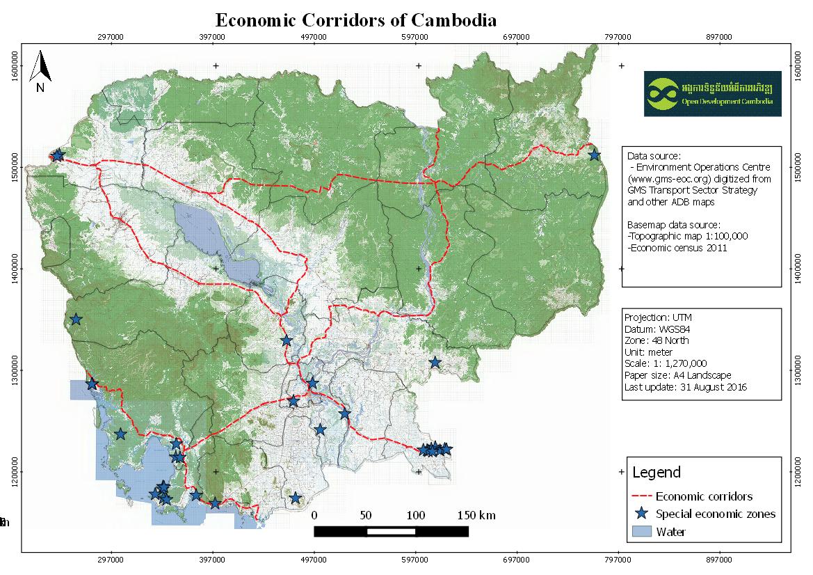
Economic corridors of Cambodia
พิมพ์โดย: Open Development Cambodia
ทรัพยากรข้อมูล (6)
ตัวอย่างทรัพยากรข้อมูล - Economic corridors of Cambodia
ข้อมูลเพิ่มเติม
| ฟิลด์ | ค่า |
|---|---|
| หมวดหมู่หัวข้อของชุดข้อมูล |
|
| ภาษา |
|
| ข้อจำกัดการใช้งาน | No access and use constraints. |
| วันที่ชุดข้อมูล | 2 มกราคม ค.ศ. 2012 |
| ชื่อทางภูมิศาสตร์ |
|
| พิกัดขอบเขตทิศตะวันตก | 102.551300048828 |
| พิกัดขอบเขตทิศตะวันออก | 107.504234313965 |
| พิกัดขอบเขตทิศใต้ | 10.4262790679932 |
| พิกัดขอบเขตทิศเหนือ | 13.9100093841553 |
| ระบบอ้างอิงเชิงพื้นที่ | WGS 84 (EPSG:4326) (CRS:84) |
| ความแม่นยำเชิงตำแหน่ง | |
| ความสอดคล้องเชิงตรรกะ | |
| ความสมบูรณ์ | |
| ขั้นตอนของกระบวนการ | The data was visualized in CartoDB and created a custom legend and information windows for data points. Subsets of this data were created for presentation at country level. |
| แหล่งที่มา | Environment Operations Centre (www.gms-eoc.org) digitized from GMS Transport Sector Strategy and other ADB maps. |
| ฝ่ายงานรับผิดชอบ | |
| ข้อมูลผู้สร้างคำอธิบายชุดข้อมูล | Metadata last updated on 2016-05-31. For inquiries contact: Open Development Cambodia Address: #43 St. 208, Phnom Penh, Cambodia. Email: contact@opendevcam.net Website: http://www.opendevcam.net |
| คุณสมบัติ | |
| สัญญาอนุญาต | unspecified |
| ลิขสิทธิ์ | Unclear copyright |
| เวอร์ชัน | 1.0 |
| วันที่อัพโหลด | กรกฎาคม 14, 2015, 10:34 (UTC) |
| แก้ไขเมื่อ | ตุลาคม 8, 2019, 16:25 (UTC) |