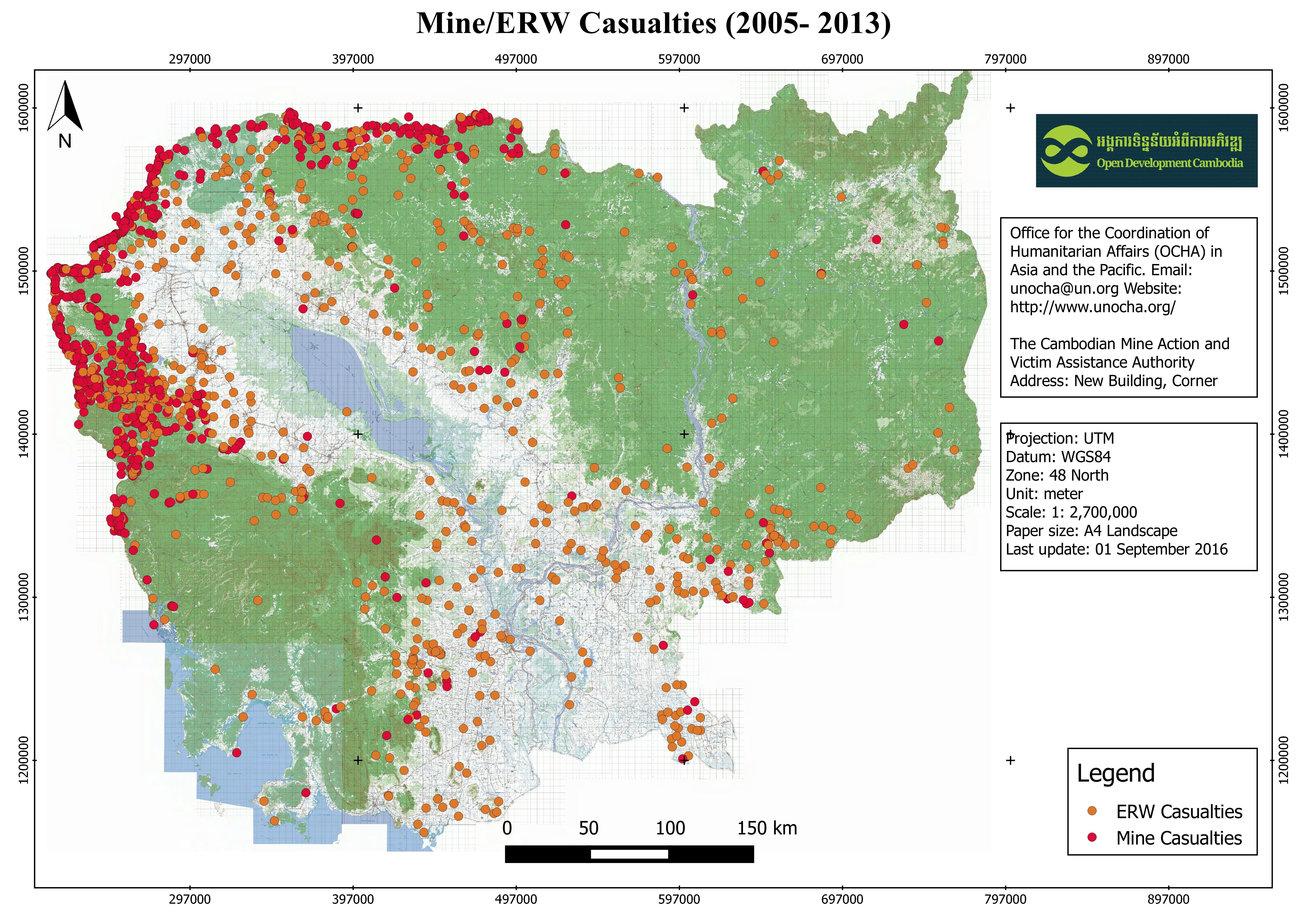
Mine/ERW casualties (2005- 2013)
พิมพ์โดย: Open Development Cambodia
ทรัพยากรข้อมูล (8)
ตัวอย่างทรัพยากรข้อมูล - Mine/ERW casualties (2005- 2013)
ข้อมูลเพิ่มเติม
| ฟิลด์ | ค่า |
|---|---|
| หมวดหมู่หัวข้อของชุดข้อมูล |
|
| ภาษา |
|
| ข้อจำกัดการใช้งาน | By accessing this website or database, users agree to take full responsibility for reliance on any site information provided and to hold harmless and waive any and all liability against individuals or entities associated with its development, form and content for any loss, harm or damage suffered as a result of its use. |
| วันที่ชุดข้อมูล | 1 มกราคม ค.ศ. 2013 |
| วันที่เริ่มใช้ขอบเขตชั่วคราว | 1 มกราคม ค.ศ. 2005 |
| วันสุดท้ายของขอบเขตชั่วคราว | 1 มกราคม ค.ศ. 2013 |
| ชื่อทางภูมิศาสตร์ |
|
| พิกัดขอบเขตทิศตะวันตก | 102.336029052734 |
| พิกัดขอบเขตทิศตะวันออก | 107.443817138672 |
| พิกัดขอบเขตทิศใต้ | 10.4554433822632 |
| พิกัดขอบเขตทิศเหนือ | 14.4457607269287 |
| ระบบอ้างอิงเชิงพื้นที่ | WGS 84 (EPSG:4326) (CRS:84) |
| ความแม่นยำเชิงตำแหน่ง | The baseline data was collected from OCHA website, and ODC cannot guarantee for its accuracy. |
| ขั้นตอนของกระบวนการ | Open Development Cambodia (ODC) downloaded the data from HDX (https://data.humdata.org) as ESRI shapefile. In addition to the existing file format, ODC's map and data team also created three more additional extensions: CSV, GeoJSON and KML for download. The team used CartoDB to make the data visualization layer and added the result onto ODC map explorerhttps://opendevelopmentcambodia.net/map-explorer. |
| แหล่งที่มา | Office for the Coordination of Humanitarian Affairs (OCHA) in Asia and the Pacific. Email: unocha@un.org Website: http://www.unocha.org/ The Cambodian Mine Action and Victim Assistance Authority Address: New Building, Corner Street 273 & 516, Tuol Kork Village, Tuol Sangke Quarter, Phnom Penh, Cambodia Phone / Fax: (+855) 23 880 462/ 228 265, E-mail: info@cmaa.gov.kh, Website: www.cmaa.gov.kh |
| ฝ่ายงานรับผิดชอบ | Humanitarian Data Exchange (HDX) Email: hdx@un.org . Website: https://data.humdata.org/ |
| ข้อมูลผู้สร้างคำอธิบายชุดข้อมูล | Metadata last updated on 2016-09-27. For inquiries contact: Open Development Cambodia (ODC). Address: #43 St. 208, Phnom Penh, Cambodia. Email: contact@opendevcam.net Website: http://www.opendevcam.net |
| คุณสมบัติ | Incident_D :Incident date, ProvCode: Province code, Province: Name of province, DisCode: District code, District: District code, ComCode: Commune code, Commune: Name of commune, VilCode: Village Code, Village: Name of village, Landuse: Type of mine on land use, VICTIM: Number of victim, INJURE : Number of injured, AMPUTATION : Number of amputation, KILLED: Number of killed, DEVICES: Device of explosion, ERW_TYPE: ERW Type, MINE_TYPE: Type of mine |
| สัญญาอนุญาต | Creative Commons Attribution |
| ลิขสิทธิ์ | Yes |
| เวอร์ชัน | 1.0 |
| วันที่อัพโหลด | ตุลาคม 19, 2016, 01:51 (UTC) |
| แก้ไขเมื่อ | มิถุนายน 30, 2020, 16:44 (UTC) |