| หมวดหมู่หัวข้อของชุดข้อมูล |
- Industrial mining
- Mineral processing and products
- Mining
|
| ภาษา |
|
| ข้อจำกัดการใช้งาน |
By accessing this website OD Mekong website and database users agree to take full responsibility for reliance on any site information provided and to hold harmless and waive any and all liability against individuals or entities associated with its development, form and content for any loss, harm or damage suffered as a result of its use.
|
| วันที่ชุดข้อมูล |
1 พฤศจิกายน ค.ศ. 2011
|
| วันที่เริ่มใช้ขอบเขตชั่วคราว |
1 มกราคม ค.ศ. 1995
|
| วันสุดท้ายของขอบเขตชั่วคราว |
10 มกราคม ค.ศ. 2020
|
| ชื่อทางภูมิศาสตร์ |
|
| พิกัดขอบเขตทิศตะวันตก |
102.48151075062452 |
| พิกัดขอบเขตทิศตะวันออก |
107.59293985232758 |
| พิกัดขอบเขตทิศใต้ |
10.517938918848266 |
| พิกัดขอบเขตทิศเหนือ |
14.496491382175632 |
| ระบบอ้างอิงเชิงพื้นที่ |
WGS 84 / UTM zone 48N (EPSG:32648) |
| ความแม่นยำเชิงตำแหน่ง |
There are no known issues with accuracy.
|
| ความสอดคล้องเชิงตรรกะ |
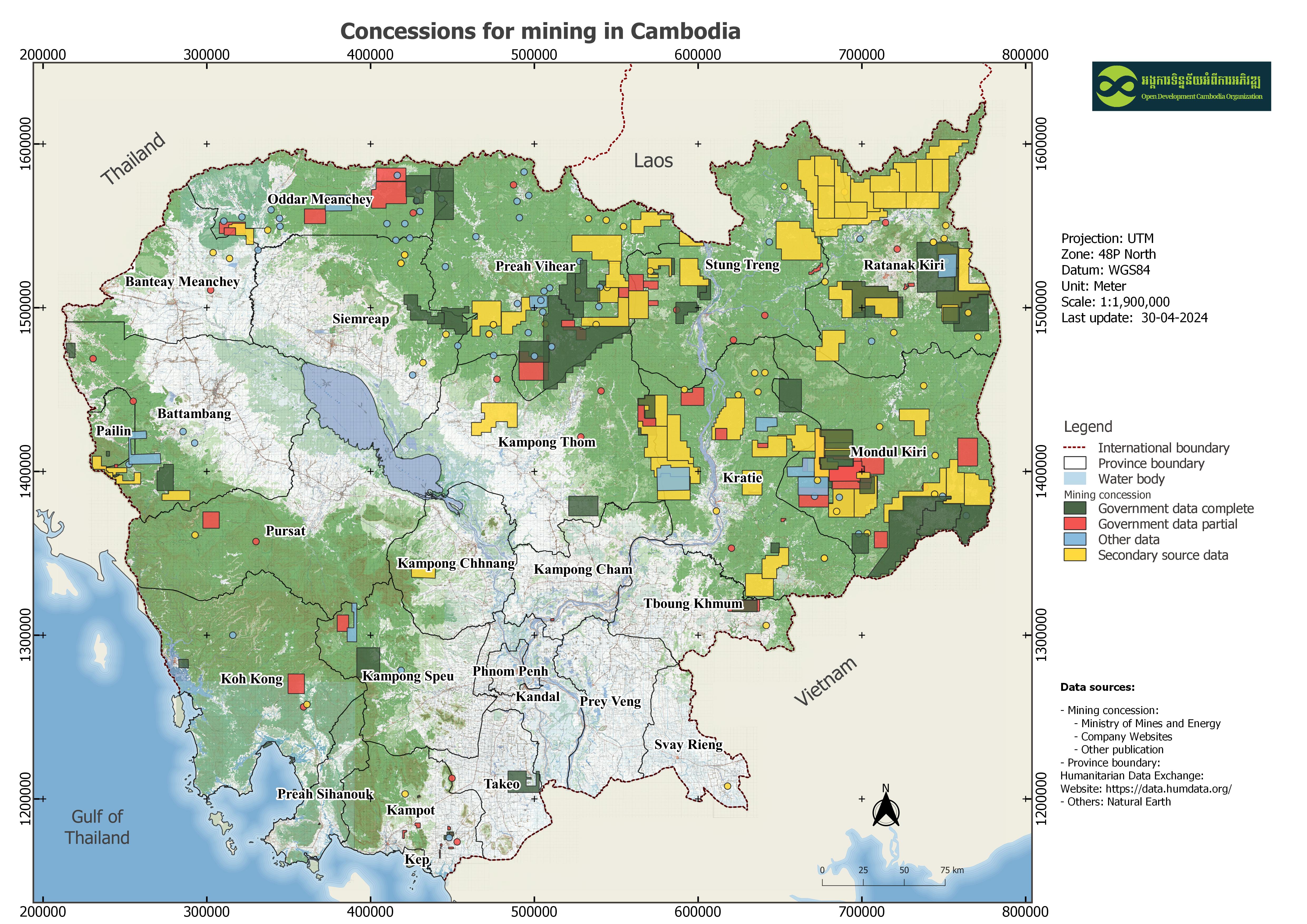
On the company website, Indochine Mining Limited holds 12 concessions in Ratanakiri province. In contrast, some sources reported the number of concessions up to 19; out of this number, 5 concessions were reportedly located in Kratie, 1 in Stung Treng and 13 in Ratanakiri. Like Indochine Mining, the website of Angkor Gold Corp lists only 7 concessions, instead of 8 concessions, by excluding the one in Siempang project.
|
| ความสมบูรณ์ |
This interactive map contains all of the data that is currently available to ODC and is not exhaustive. Projects or areas with publicly known boundaries are mapped as polygons; those without publicly known boundaries are represented as dots on the map. The dots are placed in the center of the closest known geographical area and thus do not represent exact locations. The development landscape is constantly changing, and there are also additional developments for which data is not available. While ODC takes every effort to ensure that the details in this map are accurate and up to date, some of the projects or areas marked on the map may have since been modified or cancelled since the map was published. Moreover, additional developments may have been approved that are not yet included here.
|
| ขั้นตอนของกระบวนการ |
Available data was collected from many sources by ODC’s mappers such as government documents, news, company profiles, NGO reports and other publications in pdf and shapefile formats. The data in pdf format was then transformed to shapefile format by geo referencing, and digitizing. The data in shapefile then transformed to SQLITE format was finally exported to DB_TABLE, and WMS that can download as KML, Shapefile and GEOJSON files.
|
| แหล่งที่มา |
The mining concession data available on ODC's website are from various sources:- Announcement 2017-2020 - Prakas from 1995-1997, Royal gazette;- Mining licenses from 2008-2012, Ministry of Industry Mines and Energy; - Ministry of Commerce's online database (the data were collected from the site in 2014 and 2016);- 2012 Mining company table from NGO Forum;- Company profile websites; - FA website's TWG - F&E: list of land for mineral areas 2005;- Transol Corporation's report 2012: Cambodia - New project 100% granted – Andong Bor;- Mineral company in Cambodia table, updated by EISEI in June 2012;- By 2013, 26 companies granted mining exploitation license in Preah Vihear, Cambodia Express News (CEN) reported, on March 19, 2014;- 16 companies are conducting underground metal ores exploration in Uddor Meanchey province, by Koh Santepheap Daily; - On November 19, 2013, Chinese Mining Firm Plans Siem Reap Extraction, by The Cambodia Daily; and- Mitsui Mineral Development Engineering's progress report 2009:The Master Plan Study for Promotion of the Mining Industry in the Kingdom of Cambodia.
|
| ฝ่ายงานรับผิดชอบ |
Ministry of Mines and Energy (MME)
Address: 51, 79-89 Pasteur, Sangkat Phsar Thmey3, Khan Daun Penh, Phnom Penh Tel. 023 219 574
Fax 023 219 584
E-Mail: info@mme.gov.kh
Website: www.mme.gov.kh
|
| ข้อมูลผู้สร้างคำอธิบายชุดข้อมูล |
Metadata was last updated on 2025-10-03.
For inquiries, contact: Open Development Cambodia
Email: contact@opendevcam.net
Website: http://www.opendevcam.net
Address: #23B ,St. 606, Phnom Penh, Cambodia.
|
| คุณสมบัติ |
map_id/ODC: map identification number min_name/ODC: mining concession name in_country/ODC: investor country address/ODC: company address dir_name/ODC: director name dir_nation/ODC: director nationality mining_reg/ODC: mining registration com_web/ODC: company website con_date/ODC: contract date issu_minis/ODC: issue ministry con_size_h/ODC: concession size in hectare duration/ODC: duration of mining license inv_intent/ODC: Investor intention commodity/ODC: commodity min_status/ODC: mining status imp_status/ODC: implementation status eia_date/ODC: environmental impact assessment date eia_status/ODC: environmental impact assessment status area_name/ODC: area name province/ODC: province district/ODC: district commune/ODC: commune data_class/ODC: data classification reference/ODC: reference last_updat/ODC: last update.
|
| สัญญาอนุญาต |
Creative Commons Attribution
|
| ลิขสิทธิ์ |
Yes |
| เวอร์ชัน |
1.0 |
| วันที่อัพโหลด |
พฤศจิกายน 26, 2015, 19:18 (UTC)
|
| แก้ไขเมื่อ |
ตุลาคม 3, 2025, 08:43 (UTC)
|