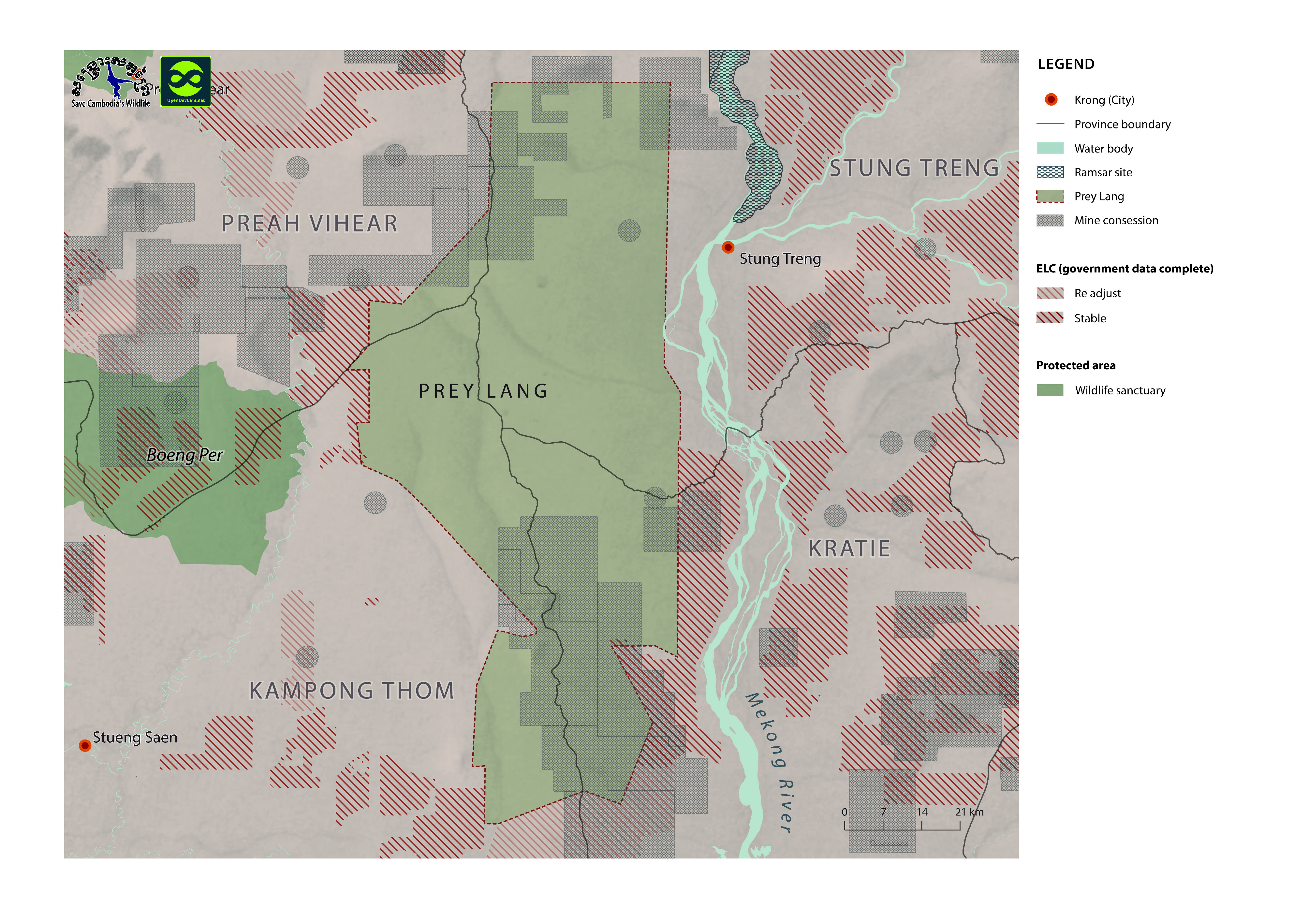
Prey Lang protected forest and biodiversity conservation area
พิมพ์โดย: Open Development Cambodia
ทรัพยากรข้อมูล (1)
ตัวอย่างทรัพยากรข้อมูล - Prey Lang protected forest and biodiversity conservation area
ข้อมูลเพิ่มเติม
| ฟิลด์ | ค่า |
|---|---|
| หมวดหมู่หัวข้อของชุดข้อมูล |
|
| ภาษา |
|
| วันที่ชุดข้อมูล | 19 มิถุนายน ค.ศ. 2014 |
| ชื่อทางภูมิศาสตร์ |
|
| ความแม่นยำเชิงตำแหน่ง | There are no known issues with accuracy. |
| ความสอดคล้องเชิงตรรกะ | There are no known issues with logical consistency. |
| ความสมบูรณ์ | There are no known issues with completeness |
| ขั้นตอนของกระบวนการ | Available data was collected from many sources by ODC’s mappers such as government, news, company profiles, reports and NGO agencies in both pdf and shapefile format. |
| แหล่งที่มา | Open Development Cambodia, contact@opendevcam.net, +855 23 221 164, http://www.opendevelopmentcambodia.net, 43 St. 208, Sangkat Boeung Riang, Khan Daun Penh, Phnom Penh, Cambodia. |
| ฝ่ายงานรับผิดชอบ | Open Development Cambodia, contact@opendevcam.net, +855 23 221 164, http://www.opendevelopmentcambodia.net, 43 St. 208, Sangkat Boeung Riang, Khan Daun Penh, Phnom Penh, Cambodia. |
| ข้อมูลผู้สร้างคำอธิบายชุดข้อมูล | Metadata last updated on 2015-12-06. For inquiries contact: Open Development Cambodia, contact@opendevcam.net http://www.opendevcam.net 43 St. 208, Phnom Penh, Cambodia. |
| สัญญาอนุญาต | CC-BY-4.0 |
| ลิขสิทธิ์ | No |
| เวอร์ชัน | 1.0 |
| วันที่อัพโหลด | ธันวาคม 6, 2015, 21:18 (UTC) |
| แก้ไขเมื่อ | มิถุนายน 13, 2018, 01:51 (UTC) |