Road and railway networks in Cambodia (2012 & 2026)
พิมพ์โดย: Open Development Cambodia
ทรัพยากรข้อมูล (13)
ตัวอย่างทรัพยากรข้อมูล - Road and railway networks in Cambodia (2012&2026)
ข้อมูลเพิ่มเติม
| ฟิลด์ | ค่า |
|---|---|
| หมวดหมู่หัวข้อของชุดข้อมูล |
|
| ภาษา |
|
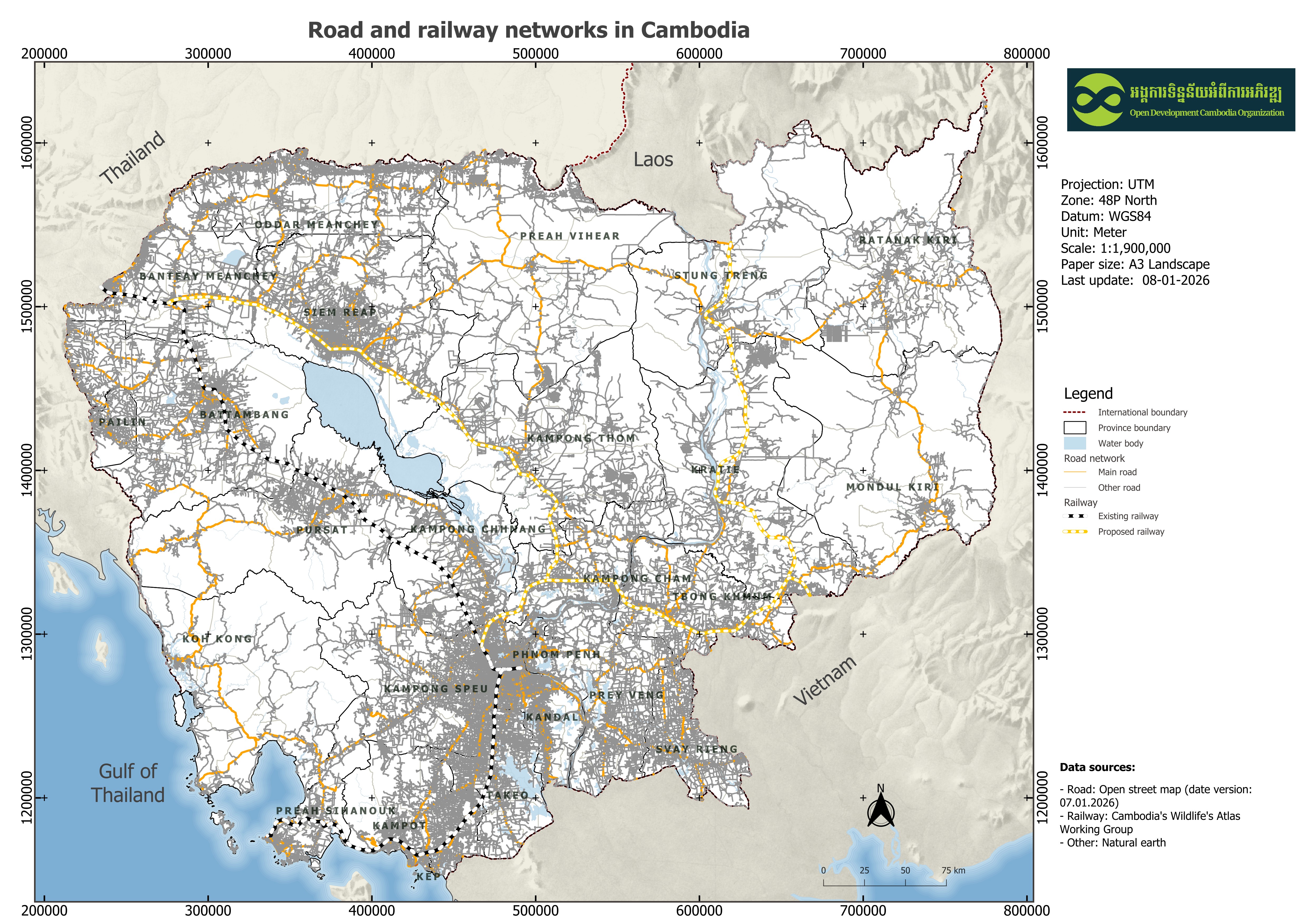
| ข้อจำกัดการใช้งาน | the data were downloaded from Open Street Map (version date: 2026-01-07) and Save Cambodia's Wildlife so it will be based on OSM and Save Cambodia's Wildlife. |
| วันที่ชุดข้อมูล | 2 มกราคม ค.ศ. 2012 |
| ชื่อทางภูมิศาสตร์ |
|
| พิกัดขอบเขตทิศตะวันตก | 102.496646980057 |
| พิกัดขอบเขตทิศตะวันออก | 107.495951712306 |
| พิกัดขอบเขตทิศใต้ | 10.4261347997216 |
| พิกัดขอบเขตทิศเหนือ | 14.434300356627 |
| ระบบอ้างอิงเชิงพื้นที่ | WGS 84 (EPSG:4326) (CRS:84) |
| ความแม่นยำเชิงตำแหน่ง | There are no known issues with accuracy |
| ความสอดคล้องเชิงตรรกะ | There are no known issues with logical consistency. |
| ความสมบูรณ์ | Open Street Map data is always up-to-date, so the completion of this data is based on Open Street Map's original data as of January 07, 2026. Whereas the 2012 railway network data in Cambodia is based on original data from Save Cambodia's Wildlife (SCW). |
| ขั้นตอนของกระบวนการ | Open Development Cambodia downloaded the data in shapefile formart as the regional level then it was clipped for Cambodia country for road network and the railway network data were provided to Open Development Cambodia directly by Save Cambodia's Wildlife's 2013 Atlas Working Group in ESRI Shapefile format to convert to GeoJSON, JPEG, and KML format. |
| แหล่งที่มา | Open Street Map, www.openstreetmap.org Save Cambodia's Wildlife. In Atlas of Cambodia: maps on socio-economic development and environment. Second ed. Phnom Penh, 2014. Print. Aruna Technology Ltd 417 Sisowath Blvd, Sangkat Chaktomuk, Phnom Penh, Cambodia Land Line: +855 (0)23 215 231 Fax: +855 (0)23 215 234 Email: info.aruna@arunatechnology.com |
| ฝ่ายงานรับผิดชอบ | Open Street Map, www.openstreetmap.org Save Cambodia's Wildlife (SCW) info@cambodiaswildlife.org +855 23 88 20 35 http://cambodiaswildlife.org 6Eo St.570, Sangkat Boeung Kak 2, Khan Tuol Kork, Phnom Penh, Cambodia. |
| ข้อมูลผู้สร้างคำอธิบายชุดข้อมูล | "Metadata last updated on 2026-01-08. For inquiries contact: Open Development Cambodia, Email: contact@opendevcam.net, Website: http://www.opendevcam.net Address: 23B St. 606, Phnom Penh, Cambodia" |
| คุณสมบัติ | status: status; source: source of the data; road_class: road classification; type: type of road |
| สัญญาอนุญาต | Creative Commons Attribution |
| ลิขสิทธิ์ | To be determined |
| เวอร์ชัน | 1.0 |
| วันที่อัพโหลด | สิงหาคม 19, 2016, 09:33 (UTC) |
| แก้ไขเมื่อ | มกราคม 8, 2026, 03:37 (UTC) |